Bure geodata
Bure (Veneto) is a populated place; located in Italy in Europe/Rome (GMT+2) time zone. With population of 668 people, there are 8500 cities with bigger population in this country. Compared to other cities in Italy, 74.5% of cities are located further ↓South; 58.9% of cities are located further →East and 61.2% of cities have higher elevation than Bure. Note1
Administrative division(s):
- Level 1: Veneto
- Level 2: Provincia di Verona
- Level 3: San Pietro in Cariano


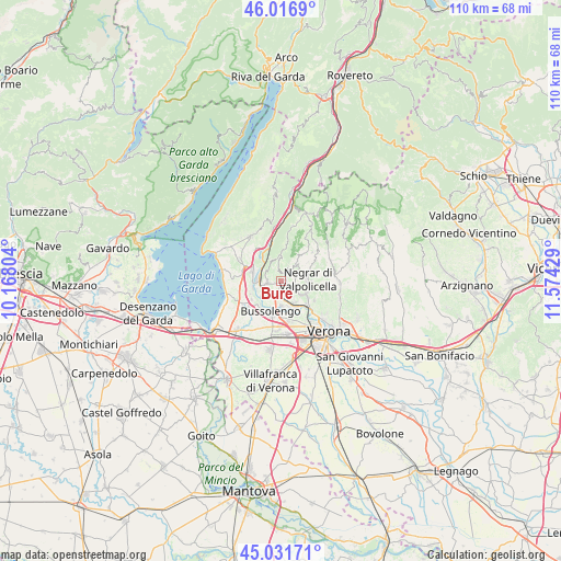
Bure GPS coordinates[2]
45° 31' 35.256" North, 10° 52' 16.176" East
| Map corner | latitude | longitude |
|---|---|---|
| Upper-left | 46.0169°, | 10.16804° |
| Center: | 45.52646°, | 10.87116° |
| Lower-right: | 45.03171°, | 11.57429° |
| Map W x H: | 109.5×109.5 km | = 68×68mi |
| max Lat: | 47.04031° ⇑25.5% North |
| Bure: | 45.52646° |
| min Lat: | ⇓74.5% South 35.50142° |
| min Long | Bure | max Long |
| 6.69888° | 10.87116° | 18.48682° |
| W 41.1%⇐ | ⇒58.9% E |
Elevation
Elevation of Bure is 154 m = 505 ft, and this is 152.7 m = 501 ft below average elevation for this country.
| Max E: |
2085 m = 6841 ft | 61.2% |
| Avg. | 306.7 m = 1006 ft | |
| Bure | 154 m = 505 ft | |
Min E: |
-4 m = -13 ft | 38.8% |
See also: Italy elevation on elevation.city.
Geographical zone
Bure is located in North temperate zone (between Tropic of Cancer and the Arctic Circle). Distance of this North polar circle is 2339.1 km =1453.4 mi to North.| Distance of | km | miles | from Bure |
|---|---|---|---|
| North Pole | 4945 | 3072.7 | to North |
| Arctic Circle | 2339.1 | 1453.4 | to North |
| Tropic Cancer | 2456.1 | 1526.1 | to South |
| Equator | 5062.1 | 3145.4 | to South |


Nearby cities:
15 places around Bure: (largest is in red/bold)
• Corrubbio
5.1 km =3.2 mi,  150°
150°
• Fumane
2 km =1.2 mi,  33°
33°
• Marano di Valpolicella
4.8 km =3 mi,  46°
46°
• Negrar
5.3 km =3.3 mi,  86°
86°
• Ospedaletto
3.3 km =2.1 mi,  222°
222°
• Pedemonte
4.5 km =2.8 mi,  125°
125°
• Pescantina
4.6 km =2.9 mi,  183°
183°
• San Floriano
3 km =1.9 mi,  108°
108°
• San Pietro in Cariano
1.5 km =0.9 mi, 130°
• Sant'Ambrogio di Valpollicella
2.8 km =1.7 mi,  257°
257°
• Santa Lucia
4.7 km =2.9 mi,  233°
233°
• Sega
5.4 km =3.4 mi, 262°
• Settimo
6 km =3.7 mi, 150°
• Valgatara
3.3 km =2.1 mi,  73°
73°
• Volargne
4.3 km =2.7 mi,  285°
285°
Sources, notices
• [Note1] Compared only with cities in Italy existing in our database
• [Src1] Map data: © OpenStreetMap contributors (CC-BY-SA)
• [Src2] Other city data from geonames.org with taken over terms of usage.
• [Src3] Geographical zone / Annual Mean Temperature by Robert A. Rohde @ Wikipedia
