Inverno geodata
Inverno (Lombardy) is a seat of a third-order administrative division; located in Italy in Europe/Rome (GMT+2) time zone. With population of 647 people, there are 8651 cities with bigger population in this country. Compared to other cities in Italy, 65% of cities are located further ↓South; 74.8% of cities are located further →East and 74.3% of cities have higher elevation than Inverno. Note1
Administrative division(s):
- Level 1: Lombardy
- Level 2: Provincia di Pavia
- Level 3: Inverno e Monteleone


Inverno GPS coordinates[2]
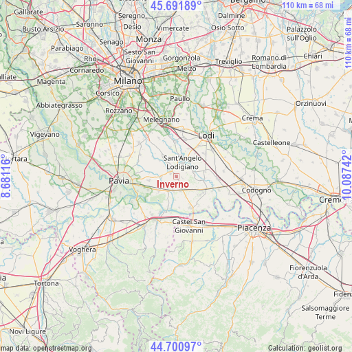
45° 11' 54.924" North, 9° 23' 3.444" East
| Map corner | latitude | longitude |
|---|---|---|
| Upper-left | 45.69189°, | 8.68116° |
| Center: | 45.19859°, | 9.38429° |
| Lower-right: | 44.70097°, | 10.08742° |
| Map W x H: | 110.2×110.2 km | = 68.5×68.5mi |
| max Lat: | 47.04031° ⇑35% North |
| Inverno: | 45.19859° |
| min Lat: | ⇓65% South 35.50142° |
| min Long | Inverno | max Long |
| 6.69888° | 9.38429° | 18.48682° |
| W 25.2%⇐ | ⇒74.8% E |
Elevation
Elevation of Inverno is 77 m = 253 ft, and this is 229.7 m = 754 ft below average elevation for this country.
| Max E: |
2085 m = 6841 ft | 74.3% |
| Avg. | 306.7 m = 1006 ft | |
| Inverno | 77 m = 253 ft | |
Min E: |
-4 m = -13 ft | 25.7% |
See also: Italy elevation on elevation.city.
Geographical zone
Inverno is located in North temperate zone (between Tropic of Cancer and the Arctic Circle). Distance of this North polar circle is 2375.6 km =1476.1 mi to North.| Distance of | km | miles | from Inverno |
|---|---|---|---|
| North Pole | 4981.4 | 3095.3 | to North |
| Arctic Circle | 2375.6 | 1476.1 | to North |
| Tropic Cancer | 2419.7 | 1503.5 | to South |
| Equator | 5025.6 | 3122.8 | to South |


Nearby cities:
15 places around Inverno: (largest is in red/bold)
• Copiano
4.7 km =2.9 mi,  268°
268°
• Corteolona
4.6 km =2.9 mi,  191°
191°
• Filighera
5.9 km =3.7 mi,  243°
243°
• Genzone
3.5 km =2.2 mi,  233°
233°
• Gerenzago
2 km =1.2 mi,  295°
295°
• Graffignana
5.6 km =3.5 mi,  80°
80°
• Inverno e Monteleone
0.1 km =0.1 mi,  136°
136°
• Magherno
5.1 km =3.2 mi, 302°
• Marudo
6.1 km =3.8 mi,  354°
354°
• Miradolo Terme
5.6 km =3.5 mi,  123°
123°
• Monteleone
2 km =1.2 mi,  105°
105°
• Sant'Angelo Lodigiano
4.4 km =2.7 mi,  23°
23°
• Santa Cristina
4.7 km =2.9 mi,  165°
165°
• Villanterio
2.8 km =1.7 mi,  319°
319°
• Vistarino
6.1 km =3.8 mi,  282°
282°
Sources, notices
• [Note1] Compared only with cities in Italy existing in our database
• [Src1] Map data: © OpenStreetMap contributors (CC-BY-SA)
• [Src2] Other city data from geonames.org with taken over terms of usage.
• [Src3] Geographical zone / Annual Mean Temperature by Robert A. Rohde @ Wikipedia
