Vigasio geodata
Vigasio (Veneto) is a seat of a third-order administrative division; located in Italy in Europe/Rome (GMT+2) time zone. With population of 6,918 people, there are 1411 cities with bigger population in this country. Compared to other cities in Italy, 67.9% of cities are located further ↓South; 58% of cities are located further →East and 83.7% of cities have higher elevation than Vigasio. Note1


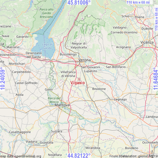
Vigasio GPS coordinates[2]
45° 19' 4.08" North, 10° 56' 37.356" East
| Map corner | latitude | longitude |
|---|---|---|
| Upper-left | 45.81006°, | 10.24059° |
| Center: | 45.3178°, | 10.94371° |
| Lower-right: | 44.82122°, | 11.64684° |
| Map W x H: | 109.9×109.9 km | = 68.3×68.3mi |
| max Lat: | 47.04031° ⇑32.1% North |
| Vigasio: | 45.3178° |
| min Lat: | ⇓67.9% South 35.50142° |
| min Long | Vigasio | max Long |
| 6.69888° | 10.94371° | 18.48682° |
| W 42%⇐ | ⇒58% E |
Elevation
Elevation of Vigasio is 35 m = 115 ft, and this is 271.7 m = 891 ft below average elevation for this country.
| Max E: |
2085 m = 6841 ft | 83.7% |
| Avg. | 306.7 m = 1006 ft | |
| Vigasio | 35 m = 115 ft | |
Min E: |
-4 m = -13 ft | 16.3% |
See also: Italy elevation on elevation.city.
Geographical zone
Vigasio is located in North temperate zone (between Tropic of Cancer and the Arctic Circle). Distance of this North polar circle is 2362.3 km =1467.9 mi to North.| Distance of | km | miles | from Vigasio |
|---|---|---|---|
| North Pole | 4968.2 | 3087.1 | to North |
| Arctic Circle | 2362.3 | 1467.9 | to North |
| Tropic Cancer | 2432.9 | 1511.7 | to South |
| Equator | 5038.9 | 3131 | to South |


Nearby cities:
15 places around Vigasio: (largest is in red/bold)
• Alpo
6.8 km =4.2 mi,  344°
344°
• Bagnolo
6.5 km =4 mi,  219°
219°
• Beccacivetta-Azzano
6.4 km =4 mi,  12°
12°
• Buttapietra
5 km =3.1 mi,  59°
59°
• Forette
2.7 km =1.7 mi,  1°
1°
• Grezzano
6.6 km =4.1 mi,  269°
269°
• Isola della Scala
7.4 km =4.6 mi,  136°
136°
• Isolalta
2.7 km =1.7 mi,  322°
322°
• Marchesino-Bovo
7 km =4.3 mi,  38°
38°
• Nogarole Rocca
5.6 km =3.5 mi,  237°
237°
• Povegliano Veronese
5.9 km =3.7 mi,  303°
303°
• Pradelle
6.9 km =4.3 mi, 235°
• Raldon
8.1 km =5 mi, 64°
• Roncolevà
7.9 km =4.9 mi,  198°
198°
• Trevenzuolo
5.4 km =3.4 mi,  188°
188°
Sources, notices
• [Note1] Compared only with cities in Italy existing in our database
• [Src1] Map data: © OpenStreetMap contributors (CC-BY-SA)
• [Src2] Other city data from geonames.org with taken over terms of usage.
• [Src3] Geographical zone / Annual Mean Temperature by Robert A. Rohde @ Wikipedia
