Trevenzuolo geodata
Trevenzuolo (Veneto) is a seat of a third-order administrative division; located in Italy in Europe/Rome (GMT+2) time zone. With population of 1,262 people, there are 5751 cities with bigger population in this country. Compared to other cities in Italy, 66.7% of cities are located further ↓South; 58.1% of cities are located further →East and 85% of cities have higher elevation than Trevenzuolo. Note1


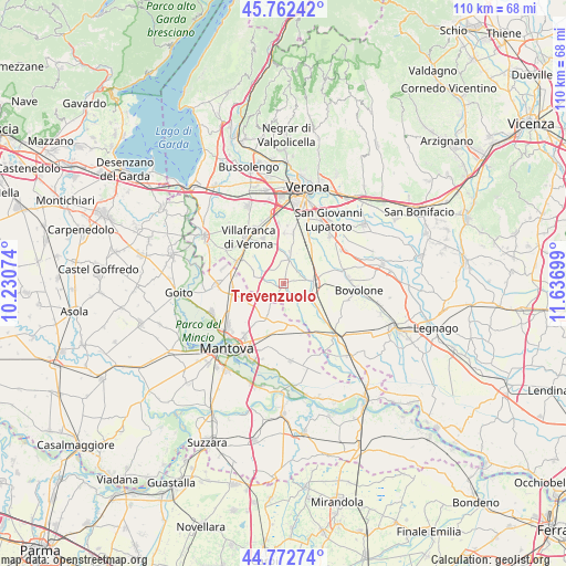
Trevenzuolo GPS coordinates[2]
45° 16' 11.064" North, 10° 56' 1.896" East
| Map corner | latitude | longitude |
|---|---|---|
| Upper-left | 45.76242°, | 10.23074° |
| Center: | 45.26974°, | 10.93386° |
| Lower-right: | 44.77274°, | 11.63699° |
| Map W x H: | 110×110 km | = 68.4×68.4mi |
| max Lat: | 47.04031° ⇑33.3% North |
| Trevenzuolo: | 45.26974° |
| min Lat: | ⇓66.7% South 35.50142° |
| min Long | Trevenzuolo | max Long |
| 6.69888° | 10.93386° | 18.48682° |
| W 41.9%⇐ | ⇒58.1% E |
Elevation
Elevation of Trevenzuolo is 31 m = 102 ft, and this is 275.7 m = 905 ft below average elevation for this country.
| Max E: |
2085 m = 6841 ft | 85% |
| Avg. | 306.7 m = 1006 ft | |
| Trevenzuolo | 31 m = 102 ft | |
Min E: |
-4 m = -13 ft | 15% |
See also: Italy elevation on elevation.city.
Geographical zone
Trevenzuolo is located in North temperate zone (between Tropic of Cancer and the Arctic Circle). Distance of this North polar circle is 2367.7 km =1471.2 mi to North.| Distance of | km | miles | from Trevenzuolo |
|---|---|---|---|
| North Pole | 4973.5 | 3090.4 | to North |
| Arctic Circle | 2367.7 | 1471.2 | to North |
| Tropic Cancer | 2427.6 | 1508.4 | to South |
| Equator | 5033.5 | 3127.7 | to South |


Nearby cities:
15 places around Trevenzuolo: (largest is in red/bold)
• Bagnolo
3.4 km =2.1 mi,  274°
274°
• Buttapietra
9.4 km =5.8 mi,  32°
32°
• Castelbelforte
7.2 km =4.5 mi,  206°
206°
• Erbè
4.2 km =2.6 mi,  136°
136°
• Forette
8.1 km =5 mi,  5°
5°
• Grezzano
7.9 km =4.9 mi,  311°
311°
• Isola della Scala
5.8 km =3.6 mi,  90°
90°
• Isolalta
7.5 km =4.7 mi,  353°
353°
• Nogarole Rocca
4.6 km =2.9 mi,  300°
300°
• Pellegrina
8.1 km =5 mi,  124°
124°
• Pradelle
5.2 km =3.2 mi,  286°
286°
• Roncolevà
2.8 km =1.7 mi,  220°
220°
• Sorgà
7.2 km =4.5 mi,  150°
150°
• Tarmassia
9.5 km =5.9 mi, 89°
• Vigasio
5.4 km =3.4 mi, 8°
Sources, notices
• [Note1] Compared only with cities in Italy existing in our database
• [Src1] Map data: © OpenStreetMap contributors (CC-BY-SA)
• [Src2] Other city data from geonames.org with taken over terms of usage.
• [Src3] Geographical zone / Annual Mean Temperature by Robert A. Rohde @ Wikipedia
