Cesio geodata
Cesio (Liguria) is a seat of a third-order administrative division; located in Italy in Europe/Rome (GMT+2) time zone. With population of 153 people, there are 11273 cities with bigger population in this country. Compared to other cities in Italy, 54.6% of cities are located further ↑North; 93.9% of cities are located further →East and 80.1% of cities have lower elevation than Cesio. Note1


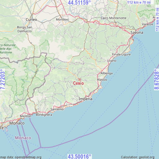
Cesio GPS coordinates[2]
44° 0' 28.908" North, 7° 58' 30.54" East
| Map corner | latitude | longitude |
|---|---|---|
| Upper-left | 44.51159°, | 7.27203° |
| Center: | 44.00803°, | 7.97515° |
| Lower-right: | 43.50016°, | 8.67828° |
| Map W x H: | 112.5×112.5 km | = 69.9×69.9mi |
| max Lat: | 47.04031° ⇑54.6% North |
| Cesio: | 44.00803° |
| min Lat: | ⇓45.4% South 35.50142° |
| min Long | Cesio | max Long |
| 6.69888° | 7.97515° | 18.48682° |
| W 6.1%⇐ | ⇒93.9% E |
Elevation
Elevation of Cesio is 527 m = 1729 ft, and this is 220.3 m = 723 ft above average elevation for this country.
| Max E: |
2085 m = 6841 ft | 19.9% |
| Cesio | 527 m 1729 ft | |
| Avg. | 306.7 m = 1006 ft | |
Min E: |
-4 m = -13 ft | 80.1% |
See also: Italy elevation on elevation.city.
Geographical zone
Cesio is located in North temperate zone (between Tropic of Cancer and the Arctic Circle). Distance of this Northern Tropic circle is 2287.3 km =1421.3 mi to South.| Distance of | km | miles | from Cesio |
|---|---|---|---|
| North Pole | 5113.8 | 3177.6 | to North |
| Arctic Circle | 2507.9 | 1558.3 | to North |
| Tropic Cancer | 2287.3 | 1421.3 | to South |
| Equator | 4893.2 | 3040.5 | to South |


Nearby cities:
15 places around Cesio: (largest is in red/bold)
• Aurigo
5 km =3.1 mi,  235°
235°
• Borghetto d'Arroscia
5.4 km =3.4 mi,  4°
4°
• Borgo di Ranzo
6.6 km =4.1 mi,  29°
29°
• Borgomaro
4.4 km =2.7 mi,  214°
214°
• Caravonica
2.2 km =1.4 mi,  219°
219°
• Casanova Lerrone
6.3 km =3.9 mi,  65°
65°
• Chiusanico
4.1 km =2.5 mi,  161°
161°
• Chiusavecchia
4.6 km =2.9 mi,  170°
170°
• Lucinasco
4.8 km =3 mi,  194°
194°
• Pieve di Teco
6.4 km =4 mi,  312°
312°
• Prelà Castello
8 km =5 mi,  198°
198°
• Rossi
6.7 km =4.2 mi,  97°
97°
• Stellanello
6.9 km =4.3 mi, 97°
• Testico
4.1 km =2.5 mi,  93°
93°
• Vessalico
4.3 km =2.7 mi,  343°
343°
Sources, notices
• [Note1] Compared only with cities in Italy existing in our database
• [Src1] Map data: © OpenStreetMap contributors (CC-BY-SA)
• [Src2] Other city data from geonames.org with taken over terms of usage.
• [Src3] Geographical zone / Annual Mean Temperature by Robert A. Rohde @ Wikipedia
