Borgomaro geodata
Borgomaro (Liguria) is a seat of a third-order administrative division; located in Italy in Europe/Rome (GMT+2) time zone. With population of 361 people, there are 10435 cities with bigger population in this country. Compared to other cities in Italy, 54.9% of cities are located further ↑North; 94.3% of cities are located further →East and 56.2% of cities have higher elevation than Borgomaro. Note1


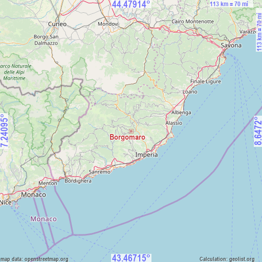
Borgomaro GPS coordinates[2]
43° 58' 31.08" North, 7° 56' 38.688" East
| Map corner | latitude | longitude |
|---|---|---|
| Upper-left | 44.47914°, | 7.24095° |
| Center: | 43.9753°, | 7.94408° |
| Lower-right: | 43.46715°, | 8.6472° |
| Map W x H: | 112.5×112.5 km | = 69.9×69.9mi |
| max Lat: | 47.04031° ⇑54.9% North |
| Borgomaro: | 43.9753° |
| min Lat: | ⇓45.1% South 35.50142° |
| min Long | Borgomaro | max Long |
| 6.69888° | 7.94408° | 18.48682° |
| W 5.7%⇐ | ⇒94.3% E |
Elevation
Elevation of Borgomaro is 194 m = 636 ft, and this is 112.7 m = 370 ft below average elevation for this country.
| Max E: |
2085 m = 6841 ft | 56.2% |
| Avg. | 306.7 m = 1006 ft | |
| Borgomaro | 194 m = 636 ft | |
Min E: |
-4 m = -13 ft | 43.8% |
See also: Italy elevation on elevation.city.
Geographical zone
Borgomaro is located in North temperate zone (between Tropic of Cancer and the Arctic Circle). Distance of this Northern Tropic circle is 2283.7 km =1419 mi to South.| Distance of | km | miles | from Borgomaro |
|---|---|---|---|
| North Pole | 5117.5 | 3179.9 | to North |
| Arctic Circle | 2511.6 | 1560.6 | to North |
| Tropic Cancer | 2283.7 | 1419 | to South |
| Equator | 4889.6 | 3038.3 | to South |


Nearby cities:
15 places around Borgomaro: (largest is in red/bold)
• Aurigo
1.9 km =1.2 mi,  296°
296°
• Caravonica
2.3 km =1.4 mi,  29°
29°
• Carpasio
6.4 km =4 mi,  254°
254°
• Cesio
4.4 km =2.7 mi, 34°
• Chiusanico
3.8 km =2.4 mi,  93°
93°
• Chiusavecchia
3.4 km =2.1 mi,  105°
105°
• Dolcedo
7.6 km =4.7 mi,  176°
176°
• Lucinasco
1.6 km =1 mi,  128°
128°
• Molini
5.5 km =3.4 mi, 184°
• Pontedassio
7 km =4.3 mi, 126°
• Prelà Castello
3.9 km =2.4 mi, 179°
• Rezzo
7.7 km =4.8 mi,  311°
311°
• Testico
7.4 km =4.6 mi,  62°
62°
• Vasia
4.8 km =3 mi,  170°
170°
• Vessalico
7.9 km =4.9 mi,  9°
9°
Sources, notices
• [Note1] Compared only with cities in Italy existing in our database
• [Src1] Map data: © OpenStreetMap contributors (CC-BY-SA)
• [Src2] Other city data from geonames.org with taken over terms of usage.
• [Src3] Geographical zone / Annual Mean Temperature by Robert A. Rohde @ Wikipedia
