Chiusanico geodata
Chiusanico (Liguria) is a seat of a third-order administrative division; located in Italy in Europe/Rome (GMT+2) time zone. With population of 219 people, there are 11038 cities with bigger population in this country. Compared to other cities in Italy, 54.9% of cities are located further ↑North; 93.7% of cities are located further →East and 68.2% of cities have lower elevation than Chiusanico. Note1


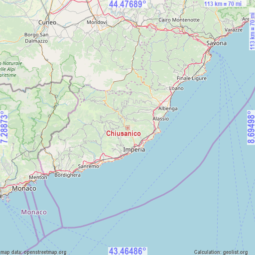
Chiusanico GPS coordinates[2]
43° 58' 22.908" North, 7° 59' 30.66" East
| Map corner | latitude | longitude |
|---|---|---|
| Upper-left | 44.47689°, | 7.28873° |
| Center: | 43.97303°, | 7.99185° |
| Lower-right: | 43.46486°, | 8.69498° |
| Map W x H: | 112.5×112.5 km | = 69.9×69.9mi |
| max Lat: | 47.04031° ⇑54.9% North |
| Chiusanico: | 43.97303° |
| min Lat: | ⇓45.1% South 35.50142° |
| min Long | Chiusanico | max Long |
| 6.69888° | 7.99185° | 18.48682° |
| W 6.3%⇐ | ⇒93.7% E |
Elevation
Elevation of Chiusanico is 375 m = 1230 ft, and this is 68.3 m = 224 ft above average elevation for this country.
| Max E: |
2085 m = 6841 ft | 31.8% |
| Chiusanico | 375 m 1230 ft | |
| Avg. | 306.7 m = 1006 ft | |
Min E: |
-4 m = -13 ft | 68.2% |
See also: Italy elevation on elevation.city.
Geographical zone
Chiusanico is located in North temperate zone (between Tropic of Cancer and the Arctic Circle). Distance of this Northern Tropic circle is 2283.4 km =1418.8 mi to South.| Distance of | km | miles | from Chiusanico |
|---|---|---|---|
| North Pole | 5117.7 | 3180 | to North |
| Arctic Circle | 2511.8 | 1560.8 | to North |
| Tropic Cancer | 2283.4 | 1418.8 | to South |
| Equator | 4889.3 | 3038.1 | to South |


Nearby cities:
15 places around Chiusanico: (largest is in red/bold)
• Aurigo
5.6 km =3.5 mi,  281°
281°
• Borgomaro
3.8 km =2.4 mi,  273°
273°
• Caravonica
3.5 km =2.2 mi,  309°
309°
• Cesio
4.1 km =2.5 mi,  341°
341°
• Chiusavecchia
0.9 km =0.6 mi,  222°
222°
• Diano Arentino
4.8 km =3 mi,  123°
123°
• Lucinasco
2.7 km =1.7 mi,  252°
252°
• Molini
6.8 km =4.2 mi, 219°
• Pontedassio
4.3 km =2.7 mi,  154°
154°
• Prelà Castello
5.3 km =3.3 mi,  226°
226°
• Rossi
6.2 km =3.9 mi,  60°
60°
• Stellanello
6.2 km =3.9 mi, 61°
• Testico
4.5 km =2.8 mi,  37°
37°
• Vasia
5.4 km =3.4 mi,  214°
214°
• Villa Faraldi
7.8 km =4.8 mi,  93°
93°
Sources, notices
• [Note1] Compared only with cities in Italy existing in our database
• [Src1] Map data: © OpenStreetMap contributors (CC-BY-SA)
• [Src2] Other city data from geonames.org with taken over terms of usage.
• [Src3] Geographical zone / Annual Mean Temperature by Robert A. Rohde @ Wikipedia
