Cervaro geodata
Cervaro (Latium) is a seat of a third-order administrative division; located in Italy in Europe/Rome (GMT+2) time zone. With population of 4,141 people, there are 2318 cities with bigger population in this country. Compared to other cities in Italy, 75% of cities are located further ↑North; 77.5% of cities are located further ←West and 50.7% of cities have lower elevation than Cervaro. Note1


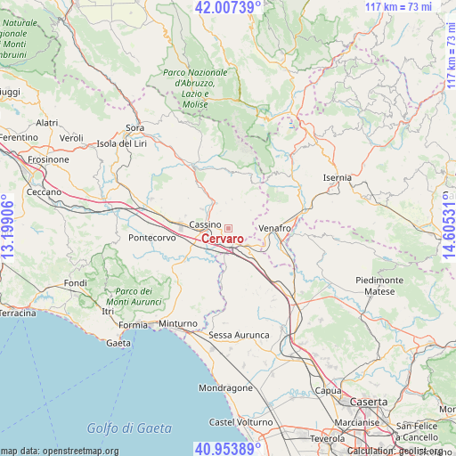
Cervaro GPS coordinates[2]
41° 28' 58.008" North, 13° 54' 7.848" East
| Map corner | latitude | longitude |
|---|---|---|
| Upper-left | 42.00739°, | 13.19906° |
| Center: | 41.48278°, | 13.90218° |
| Lower-right: | 40.95389°, | 14.60531° |
| Map W x H: | 117.1×117.1 km | = 72.8×72.8mi |
| max Lat: | 47.04031° ⇑75% North |
| Cervaro: | 41.48278° |
| min Lat: | ⇓25% South 35.50142° |
| min Long | Cervaro | max Long |
| 6.69888° | 13.90218° | 18.48682° |
| W 77.5%⇐ | ⇒22.5% E |
Elevation
Elevation of Cervaro is 239 m = 784 ft, and this is 67.7 m = 222 ft below average elevation for this country.
| Max E: |
2085 m = 6841 ft | 49.3% |
| Avg. | 306.7 m = 1006 ft | |
| Cervaro | 239 m = 784 ft | |
Min E: |
-4 m = -13 ft | 50.7% |
See also: Italy elevation on elevation.city.
Geographical zone
Cervaro is located in North temperate zone (between Tropic of Cancer and the Arctic Circle). Distance of this Northern Tropic circle is 2006.5 km =1246.8 mi to South.| Distance of | km | miles | from Cervaro |
|---|---|---|---|
| North Pole | 5394.6 | 3352 | to North |
| Arctic Circle | 2788.7 | 1732.8 | to North |
| Tropic Cancer | 2006.5 | 1246.8 | to South |
| Equator | 4612.5 | 2866.1 | to South |


Nearby cities:
15 places around Cervaro: (largest is in red/bold)
• Acquafondata
7.9 km =4.9 mi,  32°
32°
• Bivio Mortola
9.7 km =6 mi,  182°
182°
• Caira
9.1 km =5.7 mi,  308°
308°
• Cappella Morrone
2.8 km =1.7 mi,  284°
284°
• Cassino
6.2 km =3.9 mi,  273°
273°
• Ceppagna
9.7 km =6 mi,  103°
103°
• Conca Casale
8.8 km =5.5 mi,  81°
81°
• Pastenelle-Pacitti-Sprumaro
1.7 km =1.1 mi,  285°
285°
• San Bartolomeo
3.7 km =2.3 mi, 269°
• San Pietro Infine
6.4 km =4 mi,  130°
130°
• San Vittore del Lazio
3.5 km =2.2 mi, 131°
• Sant'Elia Fiumerapido
6.5 km =4 mi,  329°
329°
• Vallerotonda
7.7 km =4.8 mi,  7°
7°
• Valvori
9.1 km =5.7 mi,  353°
353°
• Viticuso
7.3 km =4.5 mi,  50°
50°
Sources, notices
• [Note1] Compared only with cities in Italy existing in our database
• [Src1] Map data: © OpenStreetMap contributors (CC-BY-SA)
• [Src2] Other city data from geonames.org with taken over terms of usage.
• [Src3] Geographical zone / Annual Mean Temperature by Robert A. Rohde @ Wikipedia
