San Brancato geodata
San Brancato (Basilicate) is a populated place; located in Italy in Europe/Rome (GMT+2) time zone. With population of 3,978 people, there are 2408 cities with bigger population in this country. Compared to other cities in Italy, 86% of cities are located further ↑North; 94.9% of cities are located further ←West and 55.4% of cities have lower elevation than San Brancato. Note1
Administrative division(s):
- Level 1: Basilicate
- Level 2: Provincia di Potenza
- Level 3: Sant'Arcangelo


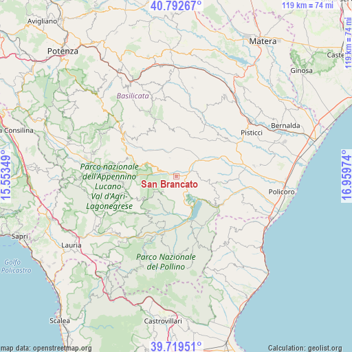
San Brancato GPS coordinates[2]
40° 15' 29.592" North, 16° 15' 23.796" East
| Map corner | latitude | longitude |
|---|---|---|
| Upper-left | 40.79267°, | 15.55349° |
| Center: | 40.25822°, | 16.25661° |
| Lower-right: | 39.71951°, | 16.95974° |
| Map W x H: | 119.3×119.3 km | = 74.1×74.1mi |
| max Lat: | 47.04031° ⇑86% North |
| San Brancato: | 40.25822° |
| min Lat: | ⇓14% South 35.50142° |
| min Long | San Brancato | max Long |
| 6.69888° | 16.25661° | 18.48682° |
| W 94.9%⇐ | ⇒5.1% E |
Elevation
Elevation of San Brancato is 268 m = 879 ft, and this is 38.7 m = 127 ft below average elevation for this country.
| Max E: |
2085 m = 6841 ft | 44.6% |
| Avg. | 306.7 m = 1006 ft | |
| San Brancato | 268 m = 879 ft | |
Min E: |
-4 m = -13 ft | 55.4% |
See also: Italy elevation on elevation.city.
Geographical zone
San Brancato is located in North temperate zone (between Tropic of Cancer and the Arctic Circle). Distance of this Northern Tropic circle is 1870.4 km =1162.2 mi to South.| Distance of | km | miles | from San Brancato |
|---|---|---|---|
| North Pole | 5530.8 | 3436.7 | to North |
| Arctic Circle | 2924.9 | 1817.4 | to North |
| Tropic Cancer | 1870.4 | 1162.2 | to South |
| Equator | 4476.3 | 2781.4 | to South |


Nearby cities:
15 places around San Brancato: (largest is in red/bold)
• Aliano
6.6 km =4.1 mi,  339°
339°
• Armento
17.1 km =10.6 mi,  288°
288°
• Calvera
15.5 km =9.6 mi,  218°
218°
• Castronuovo di Sant'Andrea
9.8 km =6.1 mi, 218°
• Chiaromonte
15.4 km =9.6 mi,  193°
193°
• Cirigliano
16.7 km =10.4 mi,  334°
334°
• Colobraro
16.3 km =10.1 mi,  118°
118°
• Gallicchio
10.9 km =6.8 mi, 290°
• Missanello
8.1 km =5 mi, 289°
• Roccanova
6.8 km =4.2 mi, 221°
• San Chirico Raparo
17 km =10.6 mi,  244°
244°
• Sant'Arcangelo
1.6 km =1 mi,  132°
132°
• Senise
12.8 km =8 mi,  167°
167°
• Stigliano
16.2 km =10.1 mi,  351°
351°
• Teana
17.2 km =10.7 mi,  210°
210°
Sources, notices
• [Note1] Compared only with cities in Italy existing in our database
• [Src1] Map data: © OpenStreetMap contributors (CC-BY-SA)
• [Src2] Other city data from geonames.org with taken over terms of usage.
• [Src3] Geographical zone / Annual Mean Temperature by Robert A. Rohde @ Wikipedia
