Rapolano Terme geodata
Rapolano Terme (Tuscany) is a seat of a third-order administrative division; located in Italy in Europe/Rome (GMT+2) time zone. With population of 2,989 people, there are 3052 cities with bigger population in this country. Compared to other cities in Italy, 61.2% of cities are located further ↑North; 50.6% of cities are located further ←West and 60.2% of cities have lower elevation than Rapolano Terme. Note1


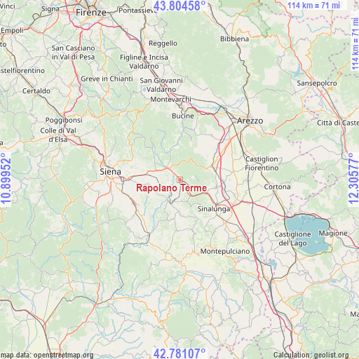
Rapolano Terme GPS coordinates[2]
43° 17' 41.928" North, 11° 36' 9.504" East
| Map corner | latitude | longitude |
|---|---|---|
| Upper-left | 43.80458°, | 10.89952° |
| Center: | 43.29498°, | 11.60264° |
| Lower-right: | 42.78107°, | 12.30577° |
| Map W x H: | 113.8×113.8 km | = 70.7×70.7mi |
| max Lat: | 47.04031° ⇑61.2% North |
| Rapolano Terme: | 43.29498° |
| min Lat: | ⇓38.8% South 35.50142° |
| min Long | Rapolano Terme | max Long |
| 6.69888° | 11.60264° | 18.48682° |
| W 50.6%⇐ | ⇒49.4% E |
Elevation
Elevation of Rapolano Terme is 300 m = 984 ft, and this is 6.7 m = 22 ft below average elevation for this country.
| Max E: |
2085 m = 6841 ft | 39.8% |
| Avg. | 306.7 m = 1006 ft | |
| Rapolano Terme | 300 m = 984 ft | |
Min E: |
-4 m = -13 ft | 60.2% |
See also: Italy elevation on elevation.city.
Geographical zone
Rapolano Terme is located in North temperate zone (between Tropic of Cancer and the Arctic Circle). Distance of this Northern Tropic circle is 2208 km =1372 mi to South.| Distance of | km | miles | from Rapolano Terme |
|---|---|---|---|
| North Pole | 5193.1 | 3226.8 | to North |
| Arctic Circle | 2587.2 | 1607.6 | to North |
| Tropic Cancer | 2208 | 1372 | to South |
| Equator | 4814 | 2991.3 | to South |


Nearby cities:
15 places around Rapolano Terme: (largest is in red/bold)
• Ambra
13.3 km =8.3 mi,  0°
0°
• Arbia
15.6 km =9.7 mi,  269°
269°
• Asciano
7.6 km =4.7 mi,  202°
202°
• Castelnuovo Berardenga
10 km =6.2 mi,  304°
304°
• Ciggiano
11.9 km =7.4 mi,  48°
48°
• Lucignano
11.9 km =7.4 mi,  102°
102°
• Marciano
15.4 km =9.6 mi,  85°
85°
• Marciano della Chiana
14.9 km =9.3 mi, 85°
• Monte San Savino
10.8 km =6.7 mi,  67°
67°
• Monteaperti
14.3 km =8.9 mi,  284°
284°
• Pozzo della Chiana
16 km =9.9 mi, 90°
• San Giovanni d'Asso
15.8 km =9.8 mi,  183°
183°
• Serre di Rapolano
4.4 km =2.7 mi,  165°
165°
• Sinalunga
14.6 km =9.1 mi,  127°
127°
• Trequanda
13.1 km =8.1 mi,  156°
156°
Sources, notices
• [Note1] Compared only with cities in Italy existing in our database
• [Src1] Map data: © OpenStreetMap contributors (CC-BY-SA)
• [Src2] Other city data from geonames.org with taken over terms of usage.
• [Src3] Geographical zone / Annual Mean Temperature by Robert A. Rohde @ Wikipedia
