Moniego geodata
Moniego (Veneto) is a populated place; located in Italy in Europe/Rome (GMT+2) time zone. With population of 1,931 people, there are 4272 cities with bigger population in this country. Compared to other cities in Italy, 75.6% of cities are located further ↓South; 57.1% of cities are located further ←West and 92.6% of cities have higher elevation than Moniego. Note1


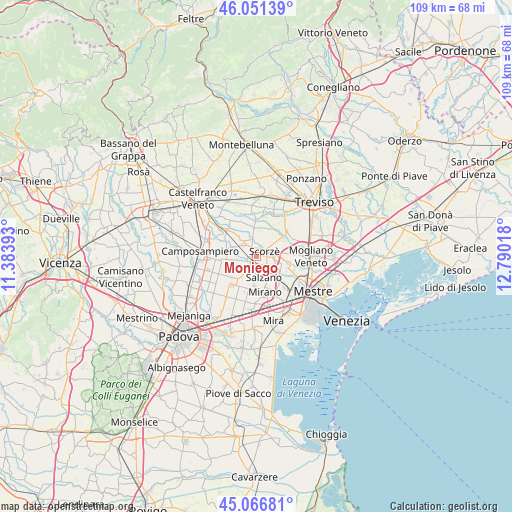
Moniego GPS coordinates[2]
45° 33' 40.536" North, 12° 5' 13.38" East
| Map corner | latitude | longitude |
|---|---|---|
| Upper-left | 46.05139°, | 11.38393° |
| Center: | 45.56126°, | 12.08705° |
| Lower-right: | 45.06681°, | 12.79018° |
| Map W x H: | 109.5×109.5 km | = 68×68mi |
| max Lat: | 47.04031° ⇑24.4% North |
| Moniego: | 45.56126° |
| min Lat: | ⇓75.6% South 35.50142° |
| min Long | Moniego | max Long |
| 6.69888° | 12.08705° | 18.48682° |
| W 57.1%⇐ | ⇒42.9% E |
Elevation
Elevation of Moniego is 13 m = 43 ft, and this is 293.7 m = 964 ft below average elevation for this country.
| Max E: |
2085 m = 6841 ft | 92.6% |
| Avg. | 306.7 m = 1006 ft | |
| Moniego | 13 m = 43 ft | |
Min E: |
-4 m = -13 ft | 7.4% |
See also: Italy elevation on elevation.city.
Geographical zone
Moniego is located in North temperate zone (between Tropic of Cancer and the Arctic Circle). Distance of this North polar circle is 2335.2 km =1451 mi to North.| Distance of | km | miles | from Moniego |
|---|---|---|---|
| North Pole | 4941.1 | 3070.3 | to North |
| Arctic Circle | 2335.2 | 1451 | to North |
| Tropic Cancer | 2460 | 1528.6 | to South |
| Equator | 5065.9 | 3147.8 | to South |


Nearby cities:
15 places around Moniego: (largest is in red/bold)
• Cappella
4.2 km =2.6 mi,  78°
78°
• Cappelletta
2.2 km =1.4 mi,  296°
296°
• Martellago
6.3 km =3.9 mi,  108°
108°
• Massanzago-Ca' Baglioni-San Dono
6.2 km =3.9 mi,  264°
264°
• Noale
2.4 km =1.5 mi,  225°
225°
• Rio San Martino
3.9 km =2.4 mi,  28°
28°
• Robegano
3.3 km =2.1 mi,  129°
129°
• Salzano
4.5 km =2.8 mi,  165°
165°
• Sant'Ambrogio
5 km =3.1 mi,  352°
352°
• Scandolara
6 km =3.7 mi,  9°
9°
• Scorzè
2.4 km =1.5 mi,  53°
53°
• Stigliano
5.4 km =3.4 mi,  218°
218°
• Trebaseleghe
4.9 km =3 mi,  316°
316°
• Veternigo
5.4 km =3.4 mi,  205°
205°
• Zeminiana
5.8 km =3.6 mi,  237°
237°
Sources, notices
• [Note1] Compared only with cities in Italy existing in our database
• [Src1] Map data: © OpenStreetMap contributors (CC-BY-SA)
• [Src2] Other city data from geonames.org with taken over terms of usage.
• [Src3] Geographical zone / Annual Mean Temperature by Robert A. Rohde @ Wikipedia
