Torremaggiore geodata
Torremaggiore (Apulia) is a seat of a third-order administrative division; located in Italy in Europe/Rome (GMT+2) time zone. With population of 16,955 people, there are 529 cities with bigger population in this country. Compared to other cities in Italy, 73% of cities are located further ↑North; 89.6% of cities are located further ←West and 59.5% of cities have higher elevation than Torremaggiore. Note1


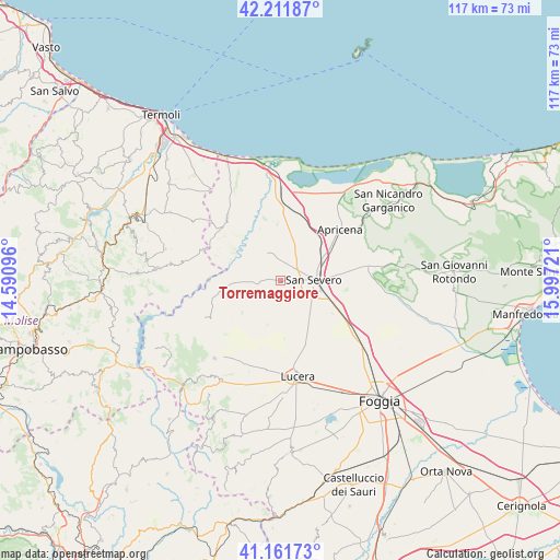
Torremaggiore GPS coordinates[2]
41° 41' 20.184" North, 15° 17' 38.688" East
| Map corner | latitude | longitude |
|---|---|---|
| Upper-left | 42.21187°, | 14.59096° |
| Center: | 41.68894°, | 15.29408° |
| Lower-right: | 41.16173°, | 15.99721° |
| Map W x H: | 116.8×116.8 km | = 72.6×72.6mi |
| max Lat: | 47.04031° ⇑73% North |
| Torremaggiore: | 41.68894° |
| min Lat: | ⇓27% South 35.50142° |
| min Long | Torremaggiore | max Long |
| 6.69888° | 15.29408° | 18.48682° |
| W 89.6%⇐ | ⇒10.4% E |
Elevation
Elevation of Torremaggiore is 167 m = 548 ft, and this is 139.7 m = 458 ft below average elevation for this country.
| Max E: |
2085 m = 6841 ft | 59.5% |
| Avg. | 306.7 m = 1006 ft | |
| Torremaggiore | 167 m = 548 ft | |
Min E: |
-4 m = -13 ft | 40.5% |
See also: Italy elevation on elevation.city.
Geographical zone
Torremaggiore is located in North temperate zone (between Tropic of Cancer and the Arctic Circle). Distance of this Northern Tropic circle is 2029.5 km =1261.1 mi to South.| Distance of | km | miles | from Torremaggiore |
|---|---|---|---|
| North Pole | 5371.7 | 3337.8 | to North |
| Arctic Circle | 2765.8 | 1718.6 | to North |
| Tropic Cancer | 2029.5 | 1261.1 | to South |
| Equator | 4635.4 | 2880.3 | to South |


Nearby cities:
15 places around Torremaggiore: (largest is in red/bold)
• Apricena
16.5 km =10.3 mi,  48°
48°
• Casalnuovo Monterotaro
17.6 km =10.9 mi,  243°
243°
• Casalvecchio di Puglia
18.5 km =11.5 mi, 235°
• Castelnuovo della Daunia
18.9 km =11.7 mi,  230°
230°
• Chieuti
20.3 km =12.6 mi,  328°
328°
• Lesina
19.8 km =12.3 mi,  14°
14°
• Lucera
20.7 km =12.9 mi,  169°
169°
• Motta Montecorvino
25.1 km =15.6 mi,  216°
216°
• Pietramontecorvino
21.3 km =13.2 mi, 220°
• Poggio Imperiale
16.3 km =10.1 mi,  21°
21°
• Rignano Garganico
24.5 km =15.2 mi,  92°
92°
• Rotello
24.8 km =15.4 mi,  285°
285°
• San Paolo di Civitate
6.2 km =3.9 mi, 333°
• San Severo
7.3 km =4.5 mi, 92°
• Serracapriola
17.3 km =10.7 mi,  320°
320°
Sources, notices
• [Note1] Compared only with cities in Italy existing in our database
• [Src1] Map data: © OpenStreetMap contributors (CC-BY-SA)
• [Src2] Other city data from geonames.org with taken over terms of usage.
• [Src3] Geographical zone / Annual Mean Temperature by Robert A. Rohde @ Wikipedia
