San Severo geodata
San Severo (Apulia) is a seat of a third-order administrative division; located in Italy in Europe/Rome (GMT+2) time zone. With population of 54,880 people, there are 99 cities with bigger population in this country. Compared to other cities in Italy, 73.1% of cities are located further ↑North; 90.1% of cities are located further ←West and 71.1% of cities have higher elevation than San Severo. Note1


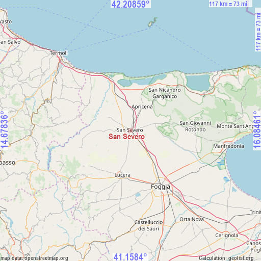
San Severo GPS coordinates[2]
41° 41' 8.304" North, 15° 22' 53.328" East
| Map corner | latitude | longitude |
|---|---|---|
| Upper-left | 42.20859°, | 14.67836° |
| Center: | 41.68564°, | 15.38148° |
| Lower-right: | 41.1584°, | 16.08461° |
| Map W x H: | 116.8×116.8 km | = 72.6×72.6mi |
| max Lat: | 47.04031° ⇑73.1% North |
| San Severo: | 41.68564° |
| min Lat: | ⇓26.9% South 35.50142° |
| min Long | San Severo | max Long |
| 6.69888° | 15.38148° | 18.48682° |
| W 90.1%⇐ | ⇒9.9% E |
Elevation
Elevation of San Severo is 92 m = 302 ft, and this is 214.7 m = 704 ft below average elevation for this country.
| Max E: |
2085 m = 6841 ft | 71.1% |
| Avg. | 306.7 m = 1006 ft | |
| San Severo | 92 m = 302 ft | |
Min E: |
-4 m = -13 ft | 28.9% |
See also: San Severo elevation on elevation.city.
Geographical zone
San Severo is located in North temperate zone (between Tropic of Cancer and the Arctic Circle). Distance of this Northern Tropic circle is 2029.1 km =1260.8 mi to South.| Distance of | km | miles | from San Severo |
|---|---|---|---|
| North Pole | 5372.1 | 3338.1 | to North |
| Arctic Circle | 2766.2 | 1718.8 | to North |
| Tropic Cancer | 2029.1 | 1260.8 | to South |
| Equator | 4635 | 2880.1 | to South |


Nearby cities:
15 places around San Severo: (largest is in red/bold)
• Apricena
12.3 km =7.6 mi,  24°
24°
• Borgo Celano
23 km =14.3 mi,  84°
84°
• Casalnuovo Monterotaro
24.2 km =15 mi,  252°
252°
• Casalvecchio di Puglia
24.7 km =15.3 mi, 245°
• Castelnuovo della Daunia
24.8 km =15.4 mi,  242°
242°
• Chieuti
25.1 km =15.6 mi,  314°
314°
• Lesina
19.7 km =12.2 mi,  353°
353°
• Lucera
20.3 km =12.6 mi,  189°
189°
• Poggio Imperiale
15.5 km =9.6 mi,  355°
355°
• Rignano Garganico
17.2 km =10.7 mi,  92°
92°
• San Marco in Lamis
21.5 km =13.4 mi, 82°
• San Paolo di Civitate
11.6 km =7.2 mi,  300°
300°
• Sannicandro Garganico
22.8 km =14.2 mi,  41°
41°
• Serracapriola
22.9 km =14.2 mi, 306°
• Torremaggiore
7.3 km =4.5 mi,  272°
272°
Sources, notices
• [Note1] Compared only with cities in Italy existing in our database
• [Src1] Map data: © OpenStreetMap contributors (CC-BY-SA)
• [Src2] Other city data from geonames.org with taken over terms of usage.
• [Src3] Geographical zone / Annual Mean Temperature by Robert A. Rohde @ Wikipedia
