Lesina geodata
Lesina (Apulia) is a seat of a third-order administrative division; located in Italy in Europe/Rome (GMT+2) time zone. With population of 5,954 people, there are 1648 cities with bigger population in this country. Compared to other cities in Italy, 71.6% of cities are located further ↑North; 89.9% of cities are located further ←West and 95.9% of cities have higher elevation than Lesina. Note1


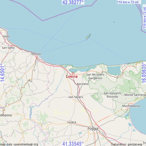
Lesina GPS coordinates[2]
41° 51' 40.5" North, 15° 21' 11.592" East
| Map corner | latitude | longitude |
|---|---|---|
| Upper-left | 42.38277°, | 14.6501° |
| Center: | 41.86125°, | 15.35322° |
| Lower-right: | 41.33545°, | 16.05635° |
| Map W x H: | 116.5×116.5 km | = 72.4×72.4mi |
| max Lat: | 47.04031° ⇑71.6% North |
| Lesina: | 41.86125° |
| min Lat: | ⇓28.4% South 35.50142° |
| min Long | Lesina | max Long |
| 6.69888° | 15.35322° | 18.48682° |
| W 89.9%⇐ | ⇒10.1% E |
Elevation
Elevation of Lesina is 7 m = 23 ft, and this is 299.7 m = 983 ft below average elevation for this country.
| Max E: |
2085 m = 6841 ft | 95.9% |
| Avg. | 306.7 m = 1006 ft | |
| Lesina | 7 m = 23 ft | |
Min E: |
-4 m = -13 ft | 4.1% |
See also: Italy elevation on elevation.city.
Geographical zone
Lesina is located in North temperate zone (between Tropic of Cancer and the Arctic Circle). Distance of this Northern Tropic circle is 2048.6 km =1272.9 mi to South.| Distance of | km | miles | from Lesina |
|---|---|---|---|
| North Pole | 5352.5 | 3325.9 | to North |
| Arctic Circle | 2746.6 | 1706.7 | to North |
| Tropic Cancer | 2048.6 | 1272.9 | to South |
| Equator | 4654.5 | 2892.2 | to South |


Nearby cities:
15 places around Lesina: (largest is in red/bold)
• Apricena
11.2 km =7 mi,  137°
137°
• Campomarino
28.4 km =17.6 mi,  292°
292°
• Chieuti
15.5 km =9.6 mi,  263°
263°
• Lido Campomarino
27.1 km =16.8 mi, 293°
• Poggio Imperiale
4.2 km =2.6 mi,  164°
164°
• Portocannone
29.1 km =18.1 mi,  281°
281°
• Rignano Garganico
28.1 km =17.5 mi, 136°
• San Marco in Lamis
28.9 km =18 mi,  125°
125°
• San Martino in Pensilis
27.8 km =17.3 mi,  273°
273°
• San Paolo di Civitate
15.6 km =9.7 mi,  209°
209°
• San Severo
19.7 km =12.2 mi,  173°
173°
• Sannicandro Garganico
17.8 km =11.1 mi,  98°
98°
• Serracapriola
16.9 km =10.5 mi,  250°
250°
• Torremaggiore
19.8 km =12.3 mi,  194°
194°
• Ururi
28.4 km =17.6 mi, 259°
Sources, notices
• [Note1] Compared only with cities in Italy existing in our database
• [Src1] Map data: © OpenStreetMap contributors (CC-BY-SA)
• [Src2] Other city data from geonames.org with taken over terms of usage.
• [Src3] Geographical zone / Annual Mean Temperature by Robert A. Rohde @ Wikipedia
