Torrebelvicino geodata
Torrebelvicino (Veneto) is a seat of a third-order administrative division; located in Italy in Europe/Rome (GMT+2) time zone. With population of 4,993 people, there are 1958 cities with bigger population in this country. Compared to other cities in Italy, 82% of cities are located further ↓South; 52.9% of cities are located further →East and 51.7% of cities have lower elevation than Torrebelvicino. Note1


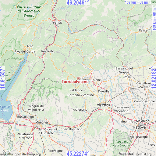
Torrebelvicino GPS coordinates[2]
45° 42' 56.988" North, 11° 19' 7.284" East
| Map corner | latitude | longitude |
|---|---|---|
| Upper-left | 46.20461°, | 10.61557° |
| Center: | 45.71583°, | 11.31869° |
| Lower-right: | 45.22274°, | 12.02182° |
| Map W x H: | 109.2×109.2 km | = 67.9×67.9mi |
| max Lat: | 47.04031° ⇑18% North |
| Torrebelvicino: | 45.71583° |
| min Lat: | ⇓82% South 35.50142° |
| min Long | Torrebelvicino | max Long |
| 6.69888° | 11.31869° | 18.48682° |
| W 47.1%⇐ | ⇒52.9% E |
Elevation
Elevation of Torrebelvicino is 245 m = 804 ft, and this is 61.7 m = 202 ft below average elevation for this country.
| Max E: |
2085 m = 6841 ft | 48.3% |
| Avg. | 306.7 m = 1006 ft | |
| Torrebelvicino | 245 m = 804 ft | |
Min E: |
-4 m = -13 ft | 51.7% |
See also: Italy elevation on elevation.city.
Geographical zone
Torrebelvicino is located in North temperate zone (between Tropic of Cancer and the Arctic Circle). Distance of this North polar circle is 2318.1 km =1440.4 mi to North.| Distance of | km | miles | from Torrebelvicino |
|---|---|---|---|
| North Pole | 4923.9 | 3059.6 | to North |
| Arctic Circle | 2318.1 | 1440.4 | to North |
| Tropic Cancer | 2477.2 | 1539.3 | to South |
| Equator | 5083.1 | 3158.5 | to South |


Nearby cities:
15 places around Torrebelvicino: (largest is in red/bold)
• Giavenale
6.6 km =4.1 mi,  105°
105°
• Malo
9.8 km =6.1 mi,  129°
129°
• Marano Vicentino
9.1 km =5.7 mi,  104°
104°
• Monte di Malo
7 km =4.3 mi,  151°
151°
• Posina
9.4 km =5.8 mi,  332°
332°
• Recoaro Terme
7.6 km =4.7 mi,  259°
259°
• San Quirico
5.6 km =3.5 mi,  219°
219°
• San Vito di Leguzzano
6.4 km =4 mi,  122°
122°
• Santorso
5.7 km =3.5 mi,  69°
69°
• Schio
3 km =1.9 mi, 96°
• Valdagno
8 km =5 mi,  191°
191°
• Valli del Pasubio
5.1 km =3.2 mi,  302°
302°
• Velo
9 km =5.6 mi,  24°
24°
• Velo d'Astico
8.9 km =5.5 mi,  25°
25°
• Zona Industriale
6.7 km =4.2 mi,  88°
88°
Sources, notices
• [Note1] Compared only with cities in Italy existing in our database
• [Src1] Map data: © OpenStreetMap contributors (CC-BY-SA)
• [Src2] Other city data from geonames.org with taken over terms of usage.
• [Src3] Geographical zone / Annual Mean Temperature by Robert A. Rohde @ Wikipedia
