Cipressa geodata
Cipressa (Liguria) is a seat of a third-order administrative division; located in Italy in Europe/Rome (GMT+2) time zone. With population of 369 people, there are 10397 cities with bigger population in this country. Compared to other cities in Italy, 56.3% of cities are located further ↑North; 94.4% of cities are located further →East and 51.4% of cities have lower elevation than Cipressa. Note1


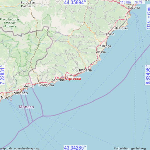
Cipressa GPS coordinates[2]
43° 51' 7.38" North, 7° 55' 53.184" East
| Map corner | latitude | longitude |
|---|---|---|
| Upper-left | 44.35694°, | 7.22831° |
| Center: | 43.85205°, | 7.93144° |
| Lower-right: | 43.34285°, | 8.63456° |
| Map W x H: | 112.8×112.8 km | = 70.1×70.1mi |
| max Lat: | 47.04031° ⇑56.3% North |
| Cipressa: | 43.85205° |
| min Lat: | ⇓43.7% South 35.50142° |
| min Long | Cipressa | max Long |
| 6.69888° | 7.93144° | 18.48682° |
| W 5.6%⇐ | ⇒94.4% E |
Elevation
Elevation of Cipressa is 243 m = 797 ft, and this is 63.7 m = 209 ft below average elevation for this country.
| Max E: |
2085 m = 6841 ft | 48.6% |
| Avg. | 306.7 m = 1006 ft | |
| Cipressa | 243 m = 797 ft | |
Min E: |
-4 m = -13 ft | 51.4% |
See also: Italy elevation on elevation.city.
Geographical zone
Cipressa is located in North temperate zone (between Tropic of Cancer and the Arctic Circle). Distance of this Northern Tropic circle is 2270 km =1410.5 mi to South.| Distance of | km | miles | from Cipressa |
|---|---|---|---|
| North Pole | 5131.2 | 3188.4 | to North |
| Arctic Circle | 2525.3 | 1569.1 | to North |
| Tropic Cancer | 2270 | 1410.5 | to South |
| Equator | 4875.9 | 3029.7 | to South |


Nearby cities:
15 places around Cipressa: (largest is in red/bold)
• Borgo Sant'Agata
8.5 km =5.3 mi,  47°
47°
• Castellaro
5.2 km =3.2 mi,  285°
285°
• Civezza
3.5 km =2.2 mi,  27°
27°
• Costarainera
0.8 km =0.5 mi,  68°
68°
• Dolcedo
6.3 km =3.9 mi,  13°
13°
• Molini
8.2 km =5.1 mi,  3°
3°
• Pietrabruna
4.7 km =2.9 mi,  331°
331°
• Poggi Inferiore Poggi Superiore
4.7 km =2.9 mi,  64°
64°
• Pompeiana
3.5 km =2.2 mi,  271°
271°
• Riva Ligure
4.4 km =2.7 mi,  250°
250°
• San Lorenzo al Mare
2.6 km =1.6 mi,  85°
85°
• Santo Stefano al Mare
3.1 km =1.9 mi,  241°
241°
• Taggia
6.4 km =4 mi,  264°
264°
• Terzorio
2.7 km =1.7 mi, 270°
• Vasia
9.1 km =5.7 mi, 11°
Sources, notices
• [Note1] Compared only with cities in Italy existing in our database
• [Src1] Map data: © OpenStreetMap contributors (CC-BY-SA)
• [Src2] Other city data from geonames.org with taken over terms of usage.
• [Src3] Geographical zone / Annual Mean Temperature by Robert A. Rohde @ Wikipedia
