Summonte geodata
Summonte (Campania) is a seat of a third-order administrative division; located in Italy in Europe/Rome (GMT+2) time zone. With population of 763 people, there are 7862 cities with bigger population in this country. Compared to other cities in Italy, 79.2% of cities are located further ↑North; 84.9% of cities are located further ←West and 89.9% of cities have lower elevation than Summonte. Note1


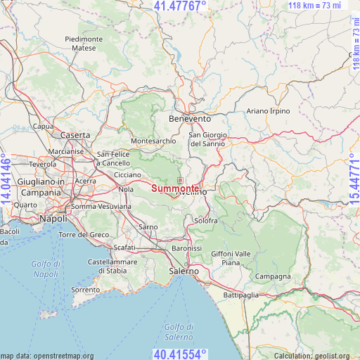
Summonte GPS coordinates[2]
40° 56' 55.464" North, 14° 44' 40.488" East
| Map corner | latitude | longitude |
|---|---|---|
| Upper-left | 41.47767°, | 14.04146° |
| Center: | 40.94874°, | 14.74458° |
| Lower-right: | 40.41554°, | 15.44771° |
| Map W x H: | 118.1×118.1 km | = 73.4×73.4mi |
| max Lat: | 47.04031° ⇑79.2% North |
| Summonte: | 40.94874° |
| min Lat: | ⇓20.8% South 35.50142° |
| min Long | Summonte | max Long |
| 6.69888° | 14.74458° | 18.48682° |
| W 84.9%⇐ | ⇒15.1% E |
Elevation
Elevation of Summonte is 717 m = 2352 ft, and this is 410.3 m = 1346 ft above average elevation for this country.
| Max E: |
2085 m = 6841 ft | 10.1% |
| Summonte | 717 m 2352 ft | |
| Avg. | 306.7 m = 1006 ft | |
Min E: |
-4 m = -13 ft | 89.9% |
See also: Italy elevation on elevation.city.
Geographical zone
Summonte is located in North temperate zone (between Tropic of Cancer and the Arctic Circle). Distance of this Northern Tropic circle is 1947.2 km =1209.9 mi to South.| Distance of | km | miles | from Summonte |
|---|---|---|---|
| North Pole | 5454 | 3389 | to North |
| Arctic Circle | 2848.1 | 1769.7 | to North |
| Tropic Cancer | 1947.2 | 1209.9 | to South |
| Equator | 4553.1 | 2829.2 | to South |


Nearby cities:
15 places around Summonte: (largest is in red/bold)
• Altavilla Irpina
7.1 km =4.4 mi,  25°
25°
• Atripalda
7.7 km =4.8 mi,  115°
115°
• Avellino
5.4 km =3.4 mi,  133°
133°
• Capriglia
3.1 km =1.9 mi,  66°
66°
• Capriglia Irpina
3 km =1.9 mi,  64°
64°
• Grottolella
4.5 km =2.8 mi, 55°
• Mercogliano
3 km =1.9 mi,  179°
179°
• Molinelle
5.3 km =3.3 mi,  163°
163°
• Monteforte Irpino
5.1 km =3.2 mi, 180°
• Montefredane
5.9 km =3.7 mi,  78°
78°
• Ospedaletto d'Alpinolo
1.1 km =0.7 mi,  171°
171°
• Pannarano
7.7 km =4.8 mi,  333°
333°
• Pietrastornina
5.6 km =3.5 mi,  336°
336°
• Sant'Angelo A Scala
2.9 km =1.8 mi,  353°
353°
• Torelli-Torrette
4.6 km =2.9 mi, 172°
Sources, notices
• [Note1] Compared only with cities in Italy existing in our database
• [Src1] Map data: © OpenStreetMap contributors (CC-BY-SA)
• [Src2] Other city data from geonames.org with taken over terms of usage.
• [Src3] Geographical zone / Annual Mean Temperature by Robert A. Rohde @ Wikipedia
