Pantano geodata
Pantano (Apulia) is a populated place; located in Italy in Europe/Rome (GMT+2) time zone. With population of 658 people, there are 8573 cities with bigger population in this country. Compared to other cities in Italy, 75.3% of cities are located further ↑North; 90.8% of cities are located further ←West and 75.6% of cities have higher elevation than Pantano. Note1


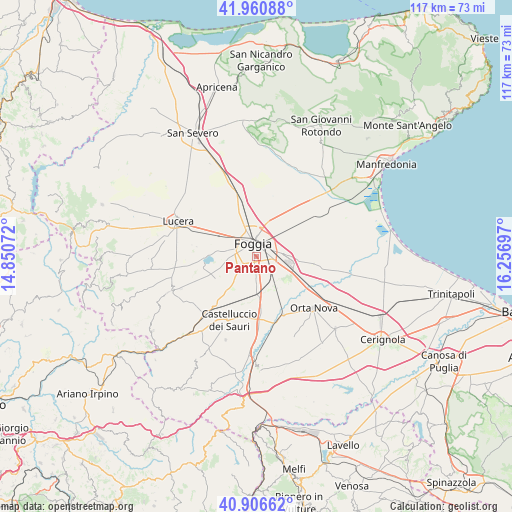
Pantano GPS coordinates[2]
41° 26' 9.204" North, 15° 33' 13.824" East
| Map corner | latitude | longitude |
|---|---|---|
| Upper-left | 41.96088°, | 14.85072° |
| Center: | 41.43589°, | 15.55384° |
| Lower-right: | 40.90662°, | 16.25697° |
| Map W x H: | 117.2×117.2 km | = 72.8×72.8mi |
| max Lat: | 47.04031° ⇑75.3% North |
| Pantano: | 41.43589° |
| min Lat: | ⇓24.7% South 35.50142° |
| min Long | Pantano | max Long |
| 6.69888° | 15.55384° | 18.48682° |
| W 90.8%⇐ | ⇒9.2% E |
Elevation
Elevation of Pantano is 71 m = 233 ft, and this is 235.7 m = 773 ft below average elevation for this country.
| Max E: |
2085 m = 6841 ft | 75.6% |
| Avg. | 306.7 m = 1006 ft | |
| Pantano | 71 m = 233 ft | |
Min E: |
-4 m = -13 ft | 24.4% |
See also: Italy elevation on elevation.city.
Geographical zone
Pantano is located in North temperate zone (between Tropic of Cancer and the Arctic Circle). Distance of this Northern Tropic circle is 2001.3 km =1243.5 mi to South.| Distance of | km | miles | from Pantano |
|---|---|---|---|
| North Pole | 5399.8 | 3355.3 | to North |
| Arctic Circle | 2793.9 | 1736 | to North |
| Tropic Cancer | 2001.3 | 1243.5 | to South |
| Equator | 4607.2 | 2862.8 | to South |


Nearby cities:
15 places around Pantano: (largest is in red/bold)
• Ascoli Satriano
25.8 km =16 mi,  177°
177°
• Biccari
30.1 km =18.7 mi,  261°
261°
• Bovino
27.4 km =17 mi,  220°
220°
• Carapelle
14.2 km =8.8 mi,  124°
124°
• Castelluccio dei Sauri
16 km =9.9 mi,  204°
204°
• Deliceto
27.6 km =17.1 mi,  210°
210°
• Foggia
2.5 km =1.6 mi,  356°
356°
• Lucera
19.5 km =12.1 mi,  293°
293°
• Ordona
14.8 km =9.2 mi,  155°
155°
• Orsara di Puglia
29.4 km =18.3 mi,  234°
234°
• Orta Nova
17.6 km =10.9 mi,  132°
132°
• Rignano Garganico
27.2 km =16.9 mi,  6°
6°
• Stornara
24.5 km =15.2 mi, 132°
• Stornarella
24.8 km =15.4 mi,  143°
143°
• Troia
21.3 km =13.2 mi,  248°
248°
Sources, notices
• [Note1] Compared only with cities in Italy existing in our database
• [Src1] Map data: © OpenStreetMap contributors (CC-BY-SA)
• [Src2] Other city data from geonames.org with taken over terms of usage.
• [Src3] Geographical zone / Annual Mean Temperature by Robert A. Rohde @ Wikipedia
