Castelluccio dei Sauri geodata
Castelluccio dei Sauri (Apulia) is a seat of a third-order administrative division; located in Italy in Europe/Rome (GMT+2) time zone. With population of 1,890 people, there are 4336 cities with bigger population in this country. Compared to other cities in Italy, 76.1% of cities are located further ↑North; 90.5% of cities are located further ←West and 57.2% of cities have lower elevation than Castelluccio dei Sauri. Note1
Administrative division(s):
- Level 1: Apulia
- Level 2: Provincia di Foggia
- Level 3: Castelluccio dei Sauri
Current local time in Castelluccio dei Sauri:
06:41 PM, WednesdayDifference from your time zone: hours


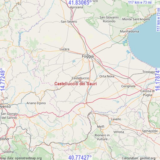
Castelluccio dei Sauri GPS coordinates[2]
41° 18' 16.56" North, 15° 28' 32.196" East
| Map corner | latitude | longitude |
|---|---|---|
| Upper-left | 41.83065°, | 14.77249° |
| Center: | 41.3046°, | 15.47561° |
| Lower-right: | 40.77427°, | 16.17874° |
| Map W x H: | 117.5×117.5 km | = 73×73mi |
| max Lat: | 47.04031° ⇑76.1% North |
| Castelluccio dei Sauri: | 41.3046° |
| min Lat: | ⇓23.9% South 35.50142° |
| min Long | Castelluccio de | max Long |
| 6.69888° | 15.47561° | 18.48682° |
| W 90.5%⇐ | ⇒9.5% E |
Elevation
Elevation of Castelluccio dei Sauri is 280 m = 919 ft, and this is 26.7 m = 88 ft below average elevation for this country.
| Max E: |
2085 m = 6841 ft | 42.8% |
| Avg. | 306.7 m = 1006 ft | |
| Castelluccio dei Sauri | 280 m = 919 ft | |
Min E: |
-4 m = -13 ft | 57.2% |
See also: Italy elevation on elevation.city.
Geographical zone
Castelluccio dei Sauri is located in North temperate zone (between Tropic of Cancer and the Arctic Circle). Distance of this Northern Tropic circle is 1986.7 km =1234.5 mi to South.| Distance of | km | miles | from Castelluccio dei Sauri |
|---|---|---|---|
| North Pole | 5414.4 | 3364.4 | to North |
| Arctic Circle | 2808.5 | 1745.1 | to North |
| Tropic Cancer | 1986.7 | 1234.5 | to South |
| Equator | 4592.6 | 2853.7 | to South |


Nearby cities:
15 places around Castelluccio dei Sauri: (largest is in red/bold)
• Accadia
20.3 km =12.6 mi,  216°
216°
• Ascoli Satriano
13.6 km =8.5 mi,  145°
145°
• Bovino
12.9 km =8 mi,  241°
241°
• Candela
19 km =11.8 mi,  169°
169°
• Carapelle
19.4 km =12.1 mi,  70°
70°
• Deliceto
11.9 km =7.4 mi, 219°
• Foggia
18.3 km =11.4 mi,  20°
20°
• Montaguto
20 km =12.4 mi,  251°
251°
• Ordona
12.8 km =8 mi,  84°
84°
• Orsara di Puglia
17.6 km =10.9 mi,  261°
261°
• Orta Nova
19.8 km =12.3 mi, 82°
• Panni
19.1 km =11.9 mi, 240°
• Pantano
16 km =9.9 mi, 24°
• Sant'Agata di Puglia
18.8 km =11.7 mi,  205°
205°
• Troia
14.8 km =9.2 mi,  296°
296°
Sources, notices
• [Note1] Compared only with cities in Italy existing in our database
• [Src1] Map data: © OpenStreetMap contributors (CC-BY-SA)
• [Src2] Other city data from geonames.org with taken over terms of usage.
• [Src3] Geographical zone / Annual Mean Temperature by Robert A. Rohde @ Wikipedia
