San Valentino alla Muta geodata
San Valentino alla Muta (Trentino-Alto Adige) is a populated place; located in Italy in Europe/Rome (GMT+2) time zone. With population of 625 people, there are 8802 cities with bigger population in this country. Compared to other cities in Italy, 99.5% of cities are located further ↓South; 62.5% of cities are located further →East and 99.6% of cities have lower elevation than San Valentino alla Muta. Note1
Current local time in San Valentino alla Muta:
06:11 PM, MondayDifference from your time zone: hours


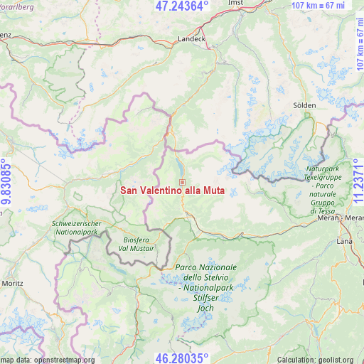
San Valentino alla Muta GPS coordinates[2]
46° 45' 50.94" North, 10° 32' 2.292" East
| Map corner | latitude | longitude |
|---|---|---|
| Upper-left | 47.24364°, | 9.83085° |
| Center: | 46.76415°, | 10.53397° |
| Lower-right: | 46.28035°, | 11.2371° |
| Map W x H: | 107.1×107.1 km | = 66.5×66.5mi |
| max Lat: | 47.04031° ⇑0.5% North |
| San Valentino alla Muta: | 46.76415° |
| min Lat: | ⇓99.5% South 35.50142° |
| min Long | San Valentino a | max Long |
| 6.69888° | 10.53397° | 18.48682° |
| W 37.5%⇐ | ⇒62.5% E |
Elevation
Elevation of San Valentino alla Muta is 1470 m = 4823 ft, and this is 1163.3 m = 3817 ft above average elevation for this country.
| Max E: |
2085 m = 6841 ft | 0.40000000000001% |
| San Valentino alla Muta | 1470 m 4823 ft | |
| Avg. | 306.7 m = 1006 ft | |
Min E: |
-4 m = -13 ft | 99.6% |
See also: Italy elevation on elevation.city.
Geographical zone
San Valentino alla Muta is located in North temperate zone (between Tropic of Cancer and the Arctic Circle). Distance of this North polar circle is 2201.5 km =1367.9 mi to North.| Distance of | km | miles | from San Valentino alla Muta |
|---|---|---|---|
| North Pole | 4807.4 | 2987.2 | to North |
| Arctic Circle | 2201.5 | 1367.9 | to North |
| Tropic Cancer | 2593.8 | 1611.7 | to South |
| Equator | 5199.7 | 3230.9 | to South |


Nearby cities:
15 places around San Valentino alla Muta: (largest is in red/bold)
• Burgusio
6 km =3.7 mi,  183°
183°
• Coldrano
27.3 km =17 mi,  125°
125°
• Curon Venosta
5 km =3.1 mi,  7°
7°
• Glorenza
10.5 km =6.5 mi,  170°
170°
• Lasa
20.5 km =12.7 mi,  142°
142°
• Laudes
9.5 km =5.9 mi, 181°
• Malles Venosta
8.5 km =5.3 mi, 173°
• Morter
28.1 km =17.5 mi, 128°
• Oris
17.2 km =10.7 mi,  150°
150°
• Prato Allo Stelvio
16.7 km =10.4 mi,  164°
164°
• Resia
7.1 km =4.4 mi,  352°
352°
• Silandro
23.4 km =14.5 mi, 130°
• Sluderno
11.6 km =7.2 mi, 161°
• Stelvio
18.5 km =11.5 mi, 177°
• Tubre
14.4 km =8.9 mi,  201°
201°
Sources, notices
• [Note1] Compared only with cities in Italy existing in our database
• [Src1] Map data: © OpenStreetMap contributors (CC-BY-SA)
• [Src2] Other city data from geonames.org with taken over terms of usage.
• [Src3] Geographical zone / Annual Mean Temperature by Robert A. Rohde @ Wikipedia
