Staffolo geodata
Staffolo (The Marches) is a seat of a third-order administrative division; located in Italy in Europe/Rome (GMT+2) time zone. With population of 1,269 people, there are 5731 cities with bigger population in this country. Compared to other cities in Italy, 60.4% of cities are located further ↑North; 70.3% of cities are located further ←West and 74.1% of cities have lower elevation than Staffolo. Note1


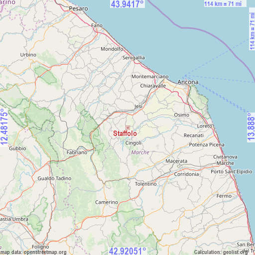
Staffolo GPS coordinates[2]
43° 25' 59.736" North, 13° 11' 5.532" East
| Map corner | latitude | longitude |
|---|---|---|
| Upper-left | 43.9417°, | 12.48175° |
| Center: | 43.43326°, | 13.18487° |
| Lower-right: | 42.92051°, | 13.888° |
| Map W x H: | 113.5×113.5 km | = 70.5×70.5mi |
| max Lat: | 47.04031° ⇑60.4% North |
| Staffolo: | 43.43326° |
| min Lat: | ⇓39.6% South 35.50142° |
| min Long | Staffolo | max Long |
| 6.69888° | 13.18487° | 18.48682° |
| W 70.3%⇐ | ⇒29.7% E |
Elevation
Elevation of Staffolo is 440 m = 1444 ft, and this is 133.3 m = 437 ft above average elevation for this country.
| Max E: |
2085 m = 6841 ft | 25.9% |
| Staffolo | 440 m 1444 ft | |
| Avg. | 306.7 m = 1006 ft | |
Min E: |
-4 m = -13 ft | 74.1% |
See also: Italy elevation on elevation.city.
Geographical zone
Staffolo is located in North temperate zone (between Tropic of Cancer and the Arctic Circle). Distance of this Northern Tropic circle is 2223.4 km =1381.6 mi to South.| Distance of | km | miles | from Staffolo |
|---|---|---|---|
| North Pole | 5177.7 | 3217.3 | to North |
| Arctic Circle | 2571.8 | 1598 | to North |
| Tropic Cancer | 2223.4 | 1381.6 | to South |
| Equator | 4829.3 | 3000.8 | to South |


Nearby cities:
15 places around Staffolo: (largest is in red/bold)
• Apiro
6.3 km =3.9 mi,  224°
224°
• Castelbellino
6.8 km =4.2 mi,  331°
331°
• Cingoli
6.7 km =4.2 mi,  163°
163°
• Cupramontana
6.1 km =3.8 mi,  287°
287°
• Macine-Borgo Loreto
9.8 km =6.1 mi,  306°
306°
• Maiolati Spontini
7.1 km =4.4 mi, 312°
• Moie
8.9 km =5.5 mi, 331°
• Monte Roberto
6.5 km =4 mi,  324°
324°
• Pianello
6.7 km =4.2 mi,  340°
340°
• Pianello Vallesina
6.4 km =4 mi, 343°
• San Paolo di Jesi
2.6 km =1.6 mi, 337°
• Scorcelletti
8.1 km =5 mi,  350°
350°
• Stazione
7.9 km =4.9 mi, 340°
• Strada
4.4 km =2.7 mi,  138°
138°
• Troviggiano
8 km =5 mi, 138°
Sources, notices
• [Note1] Compared only with cities in Italy existing in our database
• [Src1] Map data: © OpenStreetMap contributors (CC-BY-SA)
• [Src2] Other city data from geonames.org with taken over terms of usage.
• [Src3] Geographical zone / Annual Mean Temperature by Robert A. Rohde @ Wikipedia
