Castelbellino geodata
Castelbellino (The Marches) is a seat of a third-order administrative division; located in Italy in Europe/Rome (GMT+2) time zone. With population of 220 people, there are 11032 cities with bigger population in this country. Compared to other cities in Italy, 59.9% of cities are located further ↑North; 69.8% of cities are located further ←West and 52.1% of cities have lower elevation than Castelbellino. Note1
Administrative division(s):
- Level 1: The Marches
- Level 2: Provincia di Ancona
- Level 3: Castelbellino


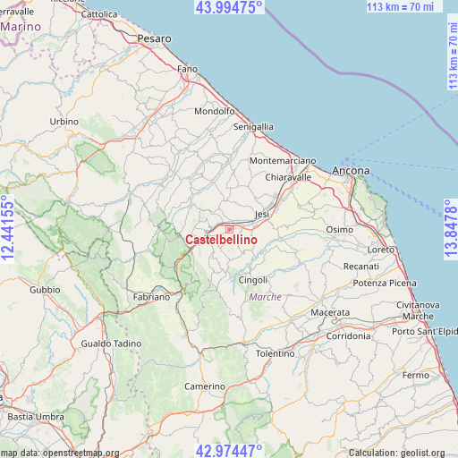
Castelbellino GPS coordinates[2]
43° 29' 12.336" North, 13° 8' 40.812" East
| Map corner | latitude | longitude |
|---|---|---|
| Upper-left | 43.99475°, | 12.44155° |
| Center: | 43.48676°, | 13.14467° |
| Lower-right: | 42.97447°, | 13.8478° |
| Map W x H: | 113.4×113.4 km | = 70.5×70.5mi |
| max Lat: | 47.04031° ⇑59.9% North |
| Castelbellino: | 43.48676° |
| min Lat: | ⇓40.1% South 35.50142° |
| min Long | Castelbellino | max Long |
| 6.69888° | 13.14467° | 18.48682° |
| W 69.8%⇐ | ⇒30.2% E |
Elevation
Elevation of Castelbellino is 247 m = 810 ft, and this is 59.7 m = 196 ft below average elevation for this country.
| Max E: |
2085 m = 6841 ft | 47.9% |
| Avg. | 306.7 m = 1006 ft | |
| Castelbellino | 247 m = 810 ft | |
Min E: |
-4 m = -13 ft | 52.1% |
See also: Italy elevation on elevation.city.
Geographical zone
Castelbellino is located in North temperate zone (between Tropic of Cancer and the Arctic Circle). Distance of this Northern Tropic circle is 2229.4 km =1385.3 mi to South.| Distance of | km | miles | from Castelbellino |
|---|---|---|---|
| North Pole | 5171.8 | 3213.6 | to North |
| Arctic Circle | 2565.9 | 1594.4 | to North |
| Tropic Cancer | 2229.4 | 1385.3 | to South |
| Equator | 4835.3 | 3004.5 | to South |


Nearby cities:
15 places around Castelbellino: (largest is in red/bold)
• Angeli
6.4 km =4 mi,  255°
255°
• Angeli Stazione
5.3 km =3.3 mi, 262°
• Castelplanio
5.1 km =3.2 mi,  279°
279°
• Cupramontana
4.8 km =3 mi,  211°
211°
• Macine-Borgo Loreto
4.6 km =2.9 mi,  269°
269°
• Maiolati Spontini
2.3 km =1.4 mi,  240°
240°
• Moie
2.1 km =1.3 mi,  332°
332°
• Monte Roberto
0.9 km =0.6 mi,  218°
218°
• Pianello
1.1 km =0.7 mi,  68°
68°
• Pianello Vallesina
1.4 km =0.9 mi,  83°
83°
• Poggio San Marcello
6.3 km =3.9 mi,  295°
295°
• Rosora
6.2 km =3.9 mi, 266°
• San Paolo di Jesi
4.2 km =2.6 mi,  147°
147°
• Scorcelletti
2.8 km =1.7 mi,  44°
44°
• Stazione
1.6 km =1 mi,  19°
19°
Sources, notices
• [Note1] Compared only with cities in Italy existing in our database
• [Src1] Map data: © OpenStreetMap contributors (CC-BY-SA)
• [Src2] Other city data from geonames.org with taken over terms of usage.
• [Src3] Geographical zone / Annual Mean Temperature by Robert A. Rohde @ Wikipedia
