Gualdo geodata
Gualdo (Emilia-Romagna) is a populated place; located in Italy in Europe/Rome (GMT+2) time zone. With population of 705 people, there are 8268 cities with bigger population in this country. Compared to other cities in Italy, 54.5% of cities are located further ↑North; 58.7% of cities are located further ←West and 70.9% of cities have higher elevation than Gualdo. Note1
Administrative division(s):
- Level 1: Emilia-Romagna
- Level 2: Provincia di Forlì-Cesena
- Level 3: Roncofreddo


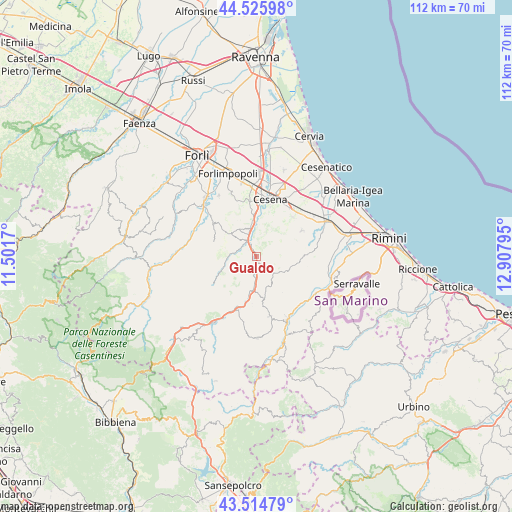
Gualdo GPS coordinates[2]
44° 1' 21.144" North, 12° 12' 17.352" East
| Map corner | latitude | longitude |
|---|---|---|
| Upper-left | 44.52598°, | 11.5017° |
| Center: | 44.02254°, | 12.20482° |
| Lower-right: | 43.51479°, | 12.90795° |
| Map W x H: | 112.4×112.4 km | = 69.8×69.8mi |
| max Lat: | 47.04031° ⇑54.5% North |
| Gualdo: | 44.02254° |
| min Lat: | ⇓45.5% South 35.50142° |
| min Long | Gualdo | max Long |
| 6.69888° | 12.20482° | 18.48682° |
| W 58.7%⇐ | ⇒41.3% E |
Elevation
Elevation of Gualdo is 93 m = 305 ft, and this is 213.7 m = 701 ft below average elevation for this country.
| Max E: |
2085 m = 6841 ft | 70.9% |
| Avg. | 306.7 m = 1006 ft | |
| Gualdo | 93 m = 305 ft | |
Min E: |
-4 m = -13 ft | 29.1% |
See also: Italy elevation on elevation.city.
Geographical zone
Gualdo is located in North temperate zone (between Tropic of Cancer and the Arctic Circle). Distance of this Northern Tropic circle is 2288.9 km =1422.3 mi to South.| Distance of | km | miles | from Gualdo |
|---|---|---|---|
| North Pole | 5112.2 | 3176.6 | to North |
| Arctic Circle | 2506.3 | 1557.3 | to North |
| Tropic Cancer | 2288.9 | 1422.3 | to South |
| Equator | 4894.8 | 3041.5 | to South |


Nearby cities:
15 places around Gualdo: (largest is in red/bold)
• Bora Bassa
3.3 km =2.1 mi,  323°
323°
• Borello
4.5 km =2.8 mi,  333°
333°
• Borghi
12.1 km =7.5 mi,  84°
84°
• Budrio
13.8 km =8.6 mi,  51°
51°
• Cesena
13.3 km =8.3 mi,  13°
13°
• Longiano
11.5 km =7.1 mi,  59°
59°
• Mercato Saraceno
6.7 km =4.2 mi,  185°
185°
• Monte Castello
8.4 km =5.2 mi, 191°
• Montiano
10.4 km =6.5 mi, 50°
• Perticara
13.3 km =8.3 mi,  167°
167°
• Roncofreddo
8 km =5 mi,  74°
74°
• Roncofreddo-Santa Paola
9.1 km =5.7 mi, 75°
• Sarsina
12.5 km =7.8 mi,  203°
203°
• Secchiano
14.1 km =8.8 mi,  140°
140°
• Sogliano al Rubicone
8 km =5 mi,  104°
104°
Sources, notices
• [Note1] Compared only with cities in Italy existing in our database
• [Src1] Map data: © OpenStreetMap contributors (CC-BY-SA)
• [Src2] Other city data from geonames.org with taken over terms of usage.
• [Src3] Geographical zone / Annual Mean Temperature by Robert A. Rohde @ Wikipedia
