Lazise geodata
Lazise (Veneto) is a seat of a third-order administrative division; located in Italy in Europe/Rome (GMT+2) time zone. With population of 3,049 people, there are 2998 cities with bigger population in this country. Compared to other cities in Italy, 73.8% of cities are located further ↓South; 60.5% of cities are located further →East and 72.3% of cities have higher elevation than Lazise. Note1


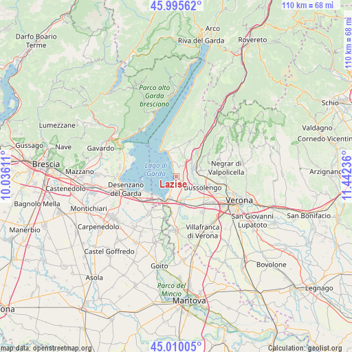
Lazise GPS coordinates[2]
45° 30' 17.964" North, 10° 44' 21.228" East
| Map corner | latitude | longitude |
|---|---|---|
| Upper-left | 45.99562°, | 10.03611° |
| Center: | 45.50499°, | 10.73923° |
| Lower-right: | 45.01005°, | 11.44236° |
| Map W x H: | 109.6×109.6 km | = 68.1×68.1mi |
| max Lat: | 47.04031° ⇑26.2% North |
| Lazise: | 45.50499° |
| min Lat: | ⇓73.8% South 35.50142° |
| min Long | Lazise | max Long |
| 6.69888° | 10.73923° | 18.48682° |
| W 39.5%⇐ | ⇒60.5% E |
Elevation
Elevation of Lazise is 86 m = 282 ft, and this is 220.7 m = 724 ft below average elevation for this country.
| Max E: |
2085 m = 6841 ft | 72.3% |
| Avg. | 306.7 m = 1006 ft | |
| Lazise | 86 m = 282 ft | |
Min E: |
-4 m = -13 ft | 27.7% |
See also: Italy elevation on elevation.city.
Geographical zone
Lazise is located in North temperate zone (between Tropic of Cancer and the Arctic Circle). Distance of this North polar circle is 2341.5 km =1454.9 mi to North.| Distance of | km | miles | from Lazise |
|---|---|---|---|
| North Pole | 4947.4 | 3074.2 | to North |
| Arctic Circle | 2341.5 | 1454.9 | to North |
| Tropic Cancer | 2453.8 | 1524.7 | to South |
| Equator | 5059.7 | 3144 | to South |


Nearby cities:
15 places around Lazise: (largest is in red/bold)
• Affi
6.5 km =4 mi,  34°
34°
• Albarè Stazione
7.6 km =4.7 mi,  9°
9°
• Bardolino
4 km =2.5 mi,  353°
353°
• Calmasino
2 km =1.2 mi, 29°
• Castelnuovo del Garda
7.5 km =4.7 mi,  167°
167°
• Cavajon Veronese
4.6 km =2.9 mi, 31°
• Cavalcaselle
7.6 km =4.7 mi,  187°
187°
• Colà
3.4 km =2.1 mi,  175°
175°
• Pastrengo
4.8 km =3 mi,  102°
102°
• Sandrà
6.2 km =3.9 mi,  143°
143°
• Sant'Ambrogio di Valpollicella
7.8 km =4.8 mi,  76°
76°
• Santa Lucia
6.5 km =4 mi,  93°
93°
• Sega
5.2 km =3.2 mi,  71°
71°
• Via Pastrengo
7.7 km =4.8 mi,  114°
114°
• Volargne
7.1 km =4.4 mi,  60°
60°
Sources, notices
• [Note1] Compared only with cities in Italy existing in our database
• [Src1] Map data: © OpenStreetMap contributors (CC-BY-SA)
• [Src2] Other city data from geonames.org with taken over terms of usage.
• [Src3] Geographical zone / Annual Mean Temperature by Robert A. Rohde @ Wikipedia
