Querciagrossa geodata
Querciagrossa (Emilia-Romagna) is a populated place; located in Italy in Europe/Rome (GMT+2) time zone. With population of 509 people, there are 9838 cities with bigger population in this country. Compared to other cities in Italy, 51.8% of cities are located further ↑North; 59.4% of cities are located further →East and 89.8% of cities have lower elevation than Querciagrossa. Note1
Administrative division(s):
- Level 1: Emilia-Romagna
- Level 2: Provincia di Modena
- Level 3: Pavullo nel Frignano


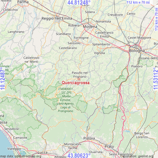
Querciagrossa GPS coordinates[2]
44° 18' 41.436" North, 10° 49' 40.764" East
| Map corner | latitude | longitude |
|---|---|---|
| Upper-left | 44.81248°, | 10.12487° |
| Center: | 44.31151°, | 10.82799° |
| Lower-right: | 43.80623°, | 11.53112° |
| Map W x H: | 111.9×111.9 km | = 69.5×69.5mi |
| max Lat: | 47.04031° ⇑51.8% North |
| Querciagrossa: | 44.31151° |
| min Lat: | ⇓48.2% South 35.50142° |
| min Long | Querciagrossa | max Long |
| 6.69888° | 10.82799° | 18.48682° |
| W 40.6%⇐ | ⇒59.4% E |
Elevation
Elevation of Querciagrossa is 714 m = 2343 ft, and this is 407.3 m = 1336 ft above average elevation for this country.
| Max E: |
2085 m = 6841 ft | 10.2% |
| Querciagrossa | 714 m 2343 ft | |
| Avg. | 306.7 m = 1006 ft | |
Min E: |
-4 m = -13 ft | 89.8% |
See also: Italy elevation on elevation.city.
Geographical zone
Querciagrossa is located in North temperate zone (between Tropic of Cancer and the Arctic Circle). Distance of this Northern Tropic circle is 2321.1 km =1442.3 mi to South.| Distance of | km | miles | from Querciagrossa |
|---|---|---|---|
| North Pole | 5080.1 | 3156.6 | to North |
| Arctic Circle | 2474.2 | 1537.4 | to North |
| Tropic Cancer | 2321.1 | 1442.3 | to South |
| Equator | 4927 | 3061.5 | to South |


Nearby cities:
15 places around Querciagrossa: (largest is in red/bold)
• Castel d'Aiano
14.3 km =8.9 mi,  105°
105°
• Fanano
11.3 km =7 mi,  192°
192°
• Gaggio Montano
15.4 km =9.6 mi,  146°
146°
• Lama
7.8 km =4.8 mi,  266°
266°
• Montecreto
11.4 km =7.1 mi,  230°
230°
• Monteombraro
15.8 km =9.8 mi,  59°
59°
• Montese
10.4 km =6.5 mi,  116°
116°
• Palagano
14.5 km =9 mi, 274°
• Pavullo nel Frignano
2.5 km =1.6 mi,  13°
13°
• Polinago
8.9 km =5.5 mi,  294°
294°
• Rocca Malatina
13.9 km =8.6 mi,  51°
51°
• Sant'Antonio
6.1 km =3.8 mi, 6°
• Serramazzoni
13.2 km =8.2 mi,  346°
346°
• Sestola
10.1 km =6.3 mi,  205°
205°
• Zocca
13.7 km =8.5 mi,  73°
73°
Sources, notices
• [Note1] Compared only with cities in Italy existing in our database
• [Src1] Map data: © OpenStreetMap contributors (CC-BY-SA)
• [Src2] Other city data from geonames.org with taken over terms of usage.
• [Src3] Geographical zone / Annual Mean Temperature by Robert A. Rohde @ Wikipedia
