Ottava geodata
Ottava (Sardinia) is a populated place; located in Italy in Europe/Rome (GMT+2) time zone. With population of 1,923 people, there are 4283 cities with bigger population in this country. Compared to other cities in Italy, 81.5% of cities are located further ↑North; 88.2% of cities are located further →East and 75.9% of cities have higher elevation than Ottava. Note1


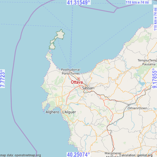
Ottava GPS coordinates[2]
40° 47' 6.9" North, 8° 28' 31.548" East
| Map corner | latitude | longitude |
|---|---|---|
| Upper-left | 41.31549°, | 7.7723° |
| Center: | 40.78525°, | 8.47543° |
| Lower-right: | 40.25074°, | 9.17855° |
| Map W x H: | 118.4×118.4 km | = 73.6×73.6mi |
| max Lat: | 47.04031° ⇑81.5% North |
| Ottava: | 40.78525° |
| min Lat: | ⇓18.5% South 35.50142° |
| min Long | Ottava | max Long |
| 6.69888° | 8.47543° | 18.48682° |
| W 11.8%⇐ | ⇒88.2% E |
Elevation
Elevation of Ottava is 70 m = 230 ft, and this is 236.7 m = 777 ft below average elevation for this country.
| Max E: |
2085 m = 6841 ft | 75.9% |
| Avg. | 306.7 m = 1006 ft | |
| Ottava | 70 m = 230 ft | |
Min E: |
-4 m = -13 ft | 24.1% |
See also: Italy elevation on elevation.city.
Geographical zone
Ottava is located in North temperate zone (between Tropic of Cancer and the Arctic Circle). Distance of this Northern Tropic circle is 1929 km =1198.6 mi to South.| Distance of | km | miles | from Ottava |
|---|---|---|---|
| North Pole | 5472.2 | 3400.3 | to North |
| Arctic Circle | 2866.3 | 1781 | to North |
| Tropic Cancer | 1929 | 1198.6 | to South |
| Equator | 4534.9 | 2817.9 | to South |


Nearby cities:
15 places around Ottava: (largest is in red/bold)
• Bancali
5.6 km =3.5 mi,  190°
190°
• Cargeghe
17.5 km =10.9 mi,  137°
137°
• Li Punti-San Giovanni
2.7 km =1.7 mi,  154°
154°
• Lu Bagnu
21.9 km =13.6 mi,  53°
53°
• Muros
16.8 km =10.4 mi,  134°
134°
• Olmedo
16.9 km =10.5 mi,  208°
208°
• Osilo
17.1 km =10.6 mi,  105°
105°
• Ossi
15.8 km =9.8 mi, 141°
• Porto Torres
8 km =5 mi,  312°
312°
• Sassari
9.4 km =5.8 mi, 134°
• Sennori
9.9 km =6.2 mi,  88°
88°
• Sorso
8.6 km =5.3 mi,  79°
79°
• Tissi
13.9 km =8.6 mi, 148°
• Uri
16.4 km =10.2 mi,  176°
176°
• Usini
14.5 km =9 mi,  158°
158°
Sources, notices
• [Note1] Compared only with cities in Italy existing in our database
• [Src1] Map data: © OpenStreetMap contributors (CC-BY-SA)
• [Src2] Other city data from geonames.org with taken over terms of usage.
• [Src3] Geographical zone / Annual Mean Temperature by Robert A. Rohde @ Wikipedia
