Mozzagrogna geodata
Mozzagrogna (Abruzzo) is a seat of a third-order administrative division; located in Italy in Europe/Rome (GMT+2) time zone. With population of 888 people, there are 7221 cities with bigger population in this country. Compared to other cities in Italy, 68.6% of cities are located further ↑North; 82.1% of cities are located further ←West and 50% of cities have lower elevation than Mozzagrogna. Note1


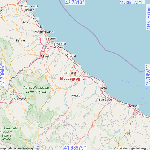
Mozzagrogna GPS coordinates[2]
42° 12' 45.612" North, 14° 26' 33.288" East
| Map corner | latitude | longitude |
|---|---|---|
| Upper-left | 42.7313°, | 13.73946° |
| Center: | 42.21267°, | 14.44258° |
| Lower-right: | 41.68975°, | 15.14571° |
| Map W x H: | 115.8×115.8 km | = 72×72mi |
| max Lat: | 47.04031° ⇑68.6% North |
| Mozzagrogna: | 42.21267° |
| min Lat: | ⇓31.4% South 35.50142° |
| min Long | Mozzagrogna | max Long |
| 6.69888° | 14.44258° | 18.48682° |
| W 82.1%⇐ | ⇒17.9% E |
Elevation
Elevation of Mozzagrogna is 235 m = 771 ft, and this is 71.7 m = 235 ft below average elevation for this country.
| Max E: |
2085 m = 6841 ft | 50% |
| Avg. | 306.7 m = 1006 ft | |
| Mozzagrogna | 235 m = 771 ft | |
Min E: |
-4 m = -13 ft | 50% |
See also: Italy elevation on elevation.city.
Geographical zone
Mozzagrogna is located in North temperate zone (between Tropic of Cancer and the Arctic Circle). Distance of this Northern Tropic circle is 2087.7 km =1297.2 mi to South.| Distance of | km | miles | from Mozzagrogna |
|---|---|---|---|
| North Pole | 5313.5 | 3301.7 | to North |
| Arctic Circle | 2707.6 | 1682.4 | to North |
| Tropic Cancer | 2087.7 | 1297.2 | to South |
| Equator | 4693.6 | 2916.5 | to South |


Nearby cities:
15 places around Mozzagrogna: (largest is in red/bold)
• Castel Frentano
7.3 km =4.5 mi,  257°
257°
• Fossacesia
4.7 km =2.9 mi,  45°
45°
• Frisa
8 km =5 mi,  317°
317°
• Lanciano
4.6 km =2.9 mi,  290°
290°
• Monte Marcone
10 km =6.2 mi,  184°
184°
• Paglieta
7.6 km =4.7 mi,  138°
138°
• Piazzano-Piana la Fara
9.8 km =6.1 mi,  195°
195°
• Rocca San Giovanni
4 km =2.5 mi,  22°
22°
• San Vito Chietino
8.6 km =5.3 mi,  0°
0°
• Sant'Amato-Nasuti
7.7 km =4.8 mi, 292°
• Sant'Apollinare
9.7 km =6 mi,  343°
343°
• Sant'Egidio
5.5 km =3.4 mi, 138°
• Santa Maria Imbaro
1 km =0.6 mi,  37°
37°
• Torino di Sangro
8.6 km =5.3 mi,  106°
106°
• Treglio
5.7 km =3.5 mi, 343°
Sources, notices
• [Note1] Compared only with cities in Italy existing in our database
• [Src1] Map data: © OpenStreetMap contributors (CC-BY-SA)
• [Src2] Other city data from geonames.org with taken over terms of usage.
• [Src3] Geographical zone / Annual Mean Temperature by Robert A. Rohde @ Wikipedia
