Sant'Angelo A Fasanella geodata
Sant'Angelo A Fasanella (Campania) is a seat of a third-order administrative division; located in Italy in Europe/Rome (GMT+2) time zone. With population of 716 people, there are 8181 cities with bigger population in this country. Compared to other cities in Italy, 84.4% of cities are located further ↑North; 89.9% of cities are located further ←West and 78.1% of cities have lower elevation than Sant'Angelo A Fasanella. Note1
Administrative division(s):
- Level 1: Campania
- Level 2: Provincia di Salerno
- Level 3: Sant'Angelo a Fasanella
Current local time in Sant'Angelo A Fasanella:
09:26 AM, WednesdayDifference from your time zone: hours


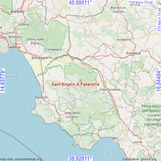
Sant'Angelo A Fasanella GPS coordinates[2]
40° 27' 26.064" North, 15° 20' 27.276" East
| Map corner | latitude | longitude |
|---|---|---|
| Upper-left | 40.99011°, | 14.63779° |
| Center: | 40.45724°, | 15.34091° |
| Lower-right: | 39.92011°, | 16.04404° |
| Map W x H: | 119×119 km | = 73.9×73.9mi |
| max Lat: | 47.04031° ⇑84.4% North |
| Sant'Angelo A Fasanella: | 40.45724° |
| min Lat: | ⇓15.6% South 35.50142° |
| min Long | Sant'Angelo A F | max Long |
| 6.69888° | 15.34091° | 18.48682° |
| W 89.9%⇐ | ⇒10.1% E |
Elevation
Elevation of Sant'Angelo A Fasanella is 494 m = 1621 ft, and this is 187.3 m = 615 ft above average elevation for this country.
| Max E: |
2085 m = 6841 ft | 21.9% |
| Sant'Angelo A Fasanella | 494 m 1621 ft | |
| Avg. | 306.7 m = 1006 ft | |
Min E: |
-4 m = -13 ft | 78.1% |
See also: Italy elevation on elevation.city.
Geographical zone
Sant'Angelo A Fasanella is located in North temperate zone (between Tropic of Cancer and the Arctic Circle). Distance of this Northern Tropic circle is 1892.5 km =1175.9 mi to South.| Distance of | km | miles | from Sant'Angelo A Fasanella |
|---|---|---|---|
| North Pole | 5508.6 | 3422.9 | to North |
| Arctic Circle | 2902.8 | 1803.7 | to North |
| Tropic Cancer | 1892.5 | 1175.9 | to South |
| Equator | 4498.4 | 2795.2 | to South |


Nearby cities:
15 places around Sant'Angelo A Fasanella: (largest is in red/bold)
• Aquara
7.5 km =4.7 mi,  258°
258°
• Bellosguardo
4.6 km =2.9 mi,  211°
211°
• Castel San Lorenzo
10.6 km =6.6 mi,  246°
246°
• Castelcivita
9.9 km =6.2 mi,  294°
294°
• Corleto Monforte
4 km =2.5 mi,  123°
123°
• Felitto
12.5 km =7.8 mi,  221°
221°
• Ottati
2.3 km =1.4 mi, 286°
• Petina
8.8 km =5.5 mi,  18°
18°
• Roscigno
6.4 km =4 mi,  176°
176°
• Sacco
9.5 km =5.9 mi,  160°
160°
• San Pietro al Tanagro
12.4 km =7.7 mi,  91°
91°
• San Rufo
10.7 km =6.6 mi,  103°
103°
• Sant'Arsenio
12.2 km =7.6 mi,  82°
82°
• Sicignano degli Alburni
11.7 km =7.3 mi,  345°
345°
• Villa Littorio
10.1 km =6.3 mi, 182°
Sources, notices
• [Note1] Compared only with cities in Italy existing in our database
• [Src1] Map data: © OpenStreetMap contributors (CC-BY-SA)
• [Src2] Other city data from geonames.org with taken over terms of usage.
• [Src3] Geographical zone / Annual Mean Temperature by Robert A. Rohde @ Wikipedia
