Pergola geodata
Pergola (The Marches) is a seat of a third-order administrative division; located in Italy in Europe/Rome (GMT+2) time zone. With population of 4,137 people, there are 2320 cities with bigger population in this country. Compared to other cities in Italy, 59.4% of cities are located further ↑North; 66.5% of cities are located further ←West and 56.6% of cities have lower elevation than Pergola. Note1
Administrative division(s):
- Level 1: The Marches
- Level 2: Provincia di Pesaro e Urbino
- Level 3: Pergola


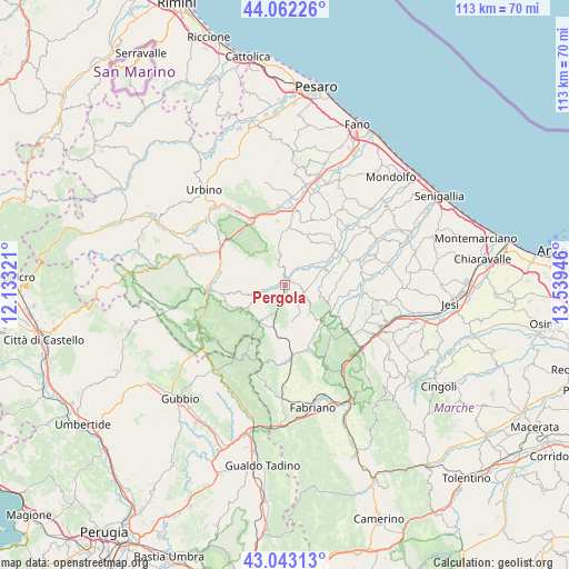
Pergola GPS coordinates[2]
43° 33' 17.46" North, 12° 50' 10.788" East
| Map corner | latitude | longitude |
|---|---|---|
| Upper-left | 44.06226°, | 12.13321° |
| Center: | 43.55485°, | 12.83633° |
| Lower-right: | 43.04313°, | 13.53946° |
| Map W x H: | 113.3×113.3 km | = 70.4×70.4mi |
| max Lat: | 47.04031° ⇑59.4% North |
| Pergola: | 43.55485° |
| min Lat: | ⇓40.6% South 35.50142° |
| min Long | Pergola | max Long |
| 6.69888° | 12.83633° | 18.48682° |
| W 66.5%⇐ | ⇒33.5% E |
Elevation
Elevation of Pergola is 276 m = 906 ft, and this is 30.7 m = 101 ft below average elevation for this country.
| Max E: |
2085 m = 6841 ft | 43.4% |
| Avg. | 306.7 m = 1006 ft | |
| Pergola | 276 m = 906 ft | |
Min E: |
-4 m = -13 ft | 56.6% |
See also: Italy elevation on elevation.city.
Geographical zone
Pergola is located in North temperate zone (between Tropic of Cancer and the Arctic Circle). Distance of this Northern Tropic circle is 2236.9 km =1389.9 mi to South.| Distance of | km | miles | from Pergola |
|---|---|---|---|
| North Pole | 5164.2 | 3208.9 | to North |
| Arctic Circle | 2558.3 | 1589.7 | to North |
| Tropic Cancer | 2236.9 | 1389.9 | to South |
| Equator | 4842.8 | 3009.2 | to South |


Nearby cities:
15 places around Pergola: (largest is in red/bold)
• Acqualagna
15.1 km =9.4 mi,  301°
301°
• Arcevia
10.6 km =6.6 mi,  123°
123°
• Barbara
15.6 km =9.7 mi,  79°
79°
• Barchi
15.1 km =9.4 mi,  29°
29°
• Cagli
14.9 km =9.3 mi,  266°
266°
• Castelleone di Suasa
12.9 km =8 mi,  62°
62°
• Fossombrone
15.2 km =9.4 mi,  352°
352°
• Fratte Rosa
10.2 km =6.3 mi, 31°
• Frontone
9.1 km =5.7 mi,  240°
240°
• Osteria
15 km =9.3 mi,  92°
92°
• Piano di Frassineta
11.6 km =7.2 mi,  175°
175°
• San Lorenzo in Campo
10.1 km =6.3 mi, 59°
• Sant'Ippolito
14.2 km =8.8 mi,  12°
12°
• Sassoferrato
13.9 km =8.6 mi,  173°
173°
• Serra Sant'Abbondio
8.6 km =5.3 mi,  215°
215°
Sources, notices
• [Note1] Compared only with cities in Italy existing in our database
• [Src1] Map data: © OpenStreetMap contributors (CC-BY-SA)
• [Src2] Other city data from geonames.org with taken over terms of usage.
• [Src3] Geographical zone / Annual Mean Temperature by Robert A. Rohde @ Wikipedia
