Colà geodata
Colà (Veneto) is a populated place; located in Italy in Europe/Rome (GMT+2) time zone. With population of 1,107 people, there are 6266 cities with bigger population in this country. Compared to other cities in Italy, 72.6% of cities are located further ↓South; 60.5% of cities are located further →East and 64.2% of cities have higher elevation than Colà. Note1


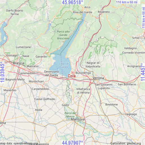
Colà GPS coordinates[2]
45° 28' 27.408" North, 10° 44' 33.252" East
| Map corner | latitude | longitude |
|---|---|---|
| Upper-left | 45.96518°, | 10.03945° |
| Center: | 45.47428°, | 10.74257° |
| Lower-right: | 44.97907°, | 11.4457° |
| Map W x H: | 109.6×109.6 km | = 68.1×68.1mi |
| max Lat: | 47.04031° ⇑27.4% North |
| Colà: | 45.47428° |
| min Lat: | ⇓72.6% South 35.50142° |
| min Long | Colà | max Long |
| 6.69888° | 10.74257° | 18.48682° |
| W 39.5%⇐ | ⇒60.5% E |
Elevation
Elevation of Colà is 133 m = 436 ft, and this is 173.7 m = 570 ft below average elevation for this country.
| Max E: |
2085 m = 6841 ft | 64.2% |
| Avg. | 306.7 m = 1006 ft | |
| Colà | 133 m = 436 ft | |
Min E: |
-4 m = -13 ft | 35.8% |
See also: Italy elevation on elevation.city.
Geographical zone
Colà is located in North temperate zone (between Tropic of Cancer and the Arctic Circle). Distance of this North polar circle is 2344.9 km =1457.1 mi to North.| Distance of | km | miles | from Colà |
|---|---|---|---|
| North Pole | 4950.8 | 3076.3 | to North |
| Arctic Circle | 2344.9 | 1457.1 | to North |
| Tropic Cancer | 2450.3 | 1522.5 | to South |
| Equator | 5056.3 | 3141.8 | to South |


Nearby cities:
15 places around Colà: (largest is in red/bold)
• Bardolino
7.5 km =4.7 mi,  354°
354°
• Calmasino
5.2 km =3.2 mi,  8°
8°
• Castelnuovo del Garda
4.2 km =2.6 mi,  161°
161°
• Cavajon Veronese
7.6 km =4.7 mi,  16°
16°
• Cavalcaselle
4.3 km =2.7 mi,  196°
196°
• Lazise
3.4 km =2.1 mi,  355°
355°
• Pastrengo
5 km =3.1 mi,  61°
61°
• Peschiera del Garda
5.9 km =3.7 mi,  228°
228°
• Ponti sul Mincio
8.2 km =5.1 mi,  212°
212°
• Salionze
7.9 km =4.9 mi,  191°
191°
• San Giorgio in Salici
6.4 km =4 mi,  145°
145°
• Sandrà
3.8 km =2.4 mi,  113°
113°
• Santa Lucia
7 km =4.3 mi, 64°
• Sega
6.9 km =4.3 mi,  42°
42°
• Via Pastrengo
6.7 km =4.2 mi,  88°
88°
Sources, notices
• [Note1] Compared only with cities in Italy existing in our database
• [Src1] Map data: © OpenStreetMap contributors (CC-BY-SA)
• [Src2] Other city data from geonames.org with taken over terms of usage.
• [Src3] Geographical zone / Annual Mean Temperature by Robert A. Rohde @ Wikipedia
