San Benedetto del Tronto geodata
San Benedetto del Tronto (The Marches) is a seat of a third-order administrative division; located in Italy in Europe/Rome (GMT+2) time zone. With population of 45,873 people, there are 143 cities with bigger population in this country. Compared to other cities in Italy, 63.6% of cities are located further ↑North; 77.3% of cities are located further ←West and 95.9% of cities have higher elevation than San Benedetto del Tronto. Note1
Administrative division(s):
- Level 1: The Marches
- Level 2: Provincia di Ascoli Piceno
- Level 3: San Benedetto del Tronto
Current local time in San Benedetto del Tronto:
05:01 AM, WednesdayDifference from your time zone: hours


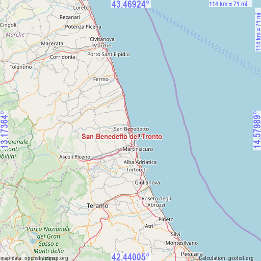
San Benedetto del Tronto GPS coordinates[2]
42° 57' 24.48" North, 13° 52' 36.336" East
| Map corner | latitude | longitude |
|---|---|---|
| Upper-left | 43.46924°, | 13.17364° |
| Center: | 42.9568°, | 13.87676° |
| Lower-right: | 42.44005°, | 14.57989° |
| Map W x H: | 114.4×114.4 km | = 71.1×71.1mi |
| max Lat: | 47.04031° ⇑63.6% North |
| San Benedetto del Tronto: | 42.9568° |
| min Lat: | ⇓36.4% South 35.50142° |
| min Long | San Benedetto d | max Long |
| 6.69888° | 13.87676° | 18.48682° |
| W 77.3%⇐ | ⇒22.7% E |
Elevation
Elevation of San Benedetto del Tronto is 7 m = 23 ft, and this is 299.7 m = 983 ft below average elevation for this country.
| Max E: |
2085 m = 6841 ft | 95.9% |
| Avg. | 306.7 m = 1006 ft | |
| San Benedetto del Tronto | 7 m = 23 ft | |
Min E: |
-4 m = -13 ft | 4.1% |
See also: San Benedetto del Tronto elevation on elevation.city.
Geographical zone
San Benedetto del Tronto is located in North temperate zone (between Tropic of Cancer and the Arctic Circle). Distance of this Northern Tropic circle is 2170.4 km =1348.6 mi to South.| Distance of | km | miles | from San Benedetto del Tronto |
|---|---|---|---|
| North Pole | 5230.7 | 3250.2 | to North |
| Arctic Circle | 2624.8 | 1631 | to North |
| Tropic Cancer | 2170.4 | 1348.6 | to South |
| Equator | 4776.3 | 2967.9 | to South |


Nearby cities:
15 places around San Benedetto del Tronto: (largest is in red/bold)
• Acquaviva Picena
4.8 km =3 mi,  247°
247°
• Centobuchi
7.2 km =4.5 mi,  198°
198°
• Colonnella
9.4 km =5.8 mi,  183°
183°
• Controguerra
12.4 km =7.7 mi, 202°
• Cupra Marittima
7 km =4.3 mi,  349°
349°
• Grottammare
2.9 km =1.8 mi, 345°
• Martinsicuro
9 km =5.6 mi,  160°
160°
• Massignano
12.2 km =7.6 mi,  328°
328°
• Monsampolo del Tronto
9.5 km =5.9 mi,  225°
225°
• Monteprandone
5.1 km =3.2 mi,  217°
217°
• Ripatransone
10.5 km =6.5 mi,  297°
297°
• San Giovanni
7.8 km =4.8 mi, 181°
• Spinetoli
11.8 km =7.3 mi, 230°
• Stella
9.5 km =5.9 mi, 215°
• Villa Rosa
12.3 km =7.6 mi, 163°
Sources, notices
• [Note1] Compared only with cities in Italy existing in our database
• [Src1] Map data: © OpenStreetMap contributors (CC-BY-SA)
• [Src2] Other city data from geonames.org with taken over terms of usage.
• [Src3] Geographical zone / Annual Mean Temperature by Robert A. Rohde @ Wikipedia
