San Giovanni geodata
San Giovanni (Abruzzo) is a populated place; located in Italy in Europe/Rome (GMT+2) time zone. With population of 621 people, there are 8833 cities with bigger population in this country. Compared to other cities in Italy, 64.1% of cities are located further ↑North; 77.3% of cities are located further ←West and 95.3% of cities have higher elevation than San Giovanni. Note1


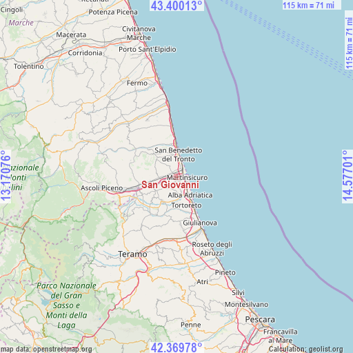
San Giovanni GPS coordinates[2]
42° 53' 13.596" North, 13° 52' 25.968" East
| Map corner | latitude | longitude |
|---|---|---|
| Upper-left | 43.40013°, | 13.17076° |
| Center: | 42.88711°, | 13.87388° |
| Lower-right: | 42.36978°, | 14.57701° |
| Map W x H: | 114.6×114.6 km | = 71.2×71.2mi |
| max Lat: | 47.04031° ⇑64.1% North |
| San Giovanni: | 42.88711° |
| min Lat: | ⇓35.9% South 35.50142° |
| min Long | San Giovanni | max Long |
| 6.69888° | 13.87388° | 18.48682° |
| W 77.3%⇐ | ⇒22.7% E |
Elevation
Elevation of San Giovanni is 8 m = 26 ft, and this is 298.7 m = 980 ft below average elevation for this country.
| Max E: |
2085 m = 6841 ft | 95.3% |
| Avg. | 306.7 m = 1006 ft | |
| San Giovanni | 8 m = 26 ft | |
Min E: |
-4 m = -13 ft | 4.7% |
See also: Italy elevation on elevation.city.
Geographical zone
San Giovanni is located in North temperate zone (between Tropic of Cancer and the Arctic Circle). Distance of this Northern Tropic circle is 2162.7 km =1343.8 mi to South.| Distance of | km | miles | from San Giovanni |
|---|---|---|---|
| North Pole | 5238.5 | 3255.1 | to North |
| Arctic Circle | 2632.6 | 1635.8 | to North |
| Tropic Cancer | 2162.7 | 1343.8 | to South |
| Equator | 4768.6 | 2963.1 | to South |


Nearby cities:
15 places around San Giovanni: (largest is in red/bold)
• Acquaviva Picena
7.3 km =4.5 mi,  324°
324°
• Alba Adriatica
7.5 km =4.7 mi,  145°
145°
• Centobuchi
2.3 km =1.4 mi,  293°
293°
• Colonnella
1.7 km =1.1 mi,  191°
191°
• Controguerra
5.9 km =3.7 mi,  231°
231°
• Corropoli
7.4 km =4.6 mi,  205°
205°
• Martinsicuro
3.3 km =2.1 mi,  103°
103°
• Monsampolo del Tronto
6.6 km =4.1 mi,  279°
279°
• Monteprandone
4.7 km =2.9 mi, 322°
• Nereto
9.1 km =5.7 mi, 208°
• Pagliare
8.8 km =5.5 mi,  256°
256°
• San Benedetto del Tronto
7.8 km =4.8 mi,  1°
1°
• Spinetoli
8.9 km =5.5 mi,  271°
271°
• Stella
5.2 km =3.2 mi, 269°
• Villa Rosa
5.5 km =3.4 mi,  137°
137°
Sources, notices
• [Note1] Compared only with cities in Italy existing in our database
• [Src1] Map data: © OpenStreetMap contributors (CC-BY-SA)
• [Src2] Other city data from geonames.org with taken over terms of usage.
• [Src3] Geographical zone / Annual Mean Temperature by Robert A. Rohde @ Wikipedia
