Salorno geodata
Salorno (Trentino-Alto Adige) is a seat of a third-order administrative division; located in Italy in Europe/Rome (GMT+2) time zone. With population of 2,783 people, there are 3232 cities with bigger population in this country. Compared to other cities in Italy, 96.4% of cities are located further ↓South; 54.3% of cities are located further →East and 53.4% of cities have higher elevation than Salorno. Note1


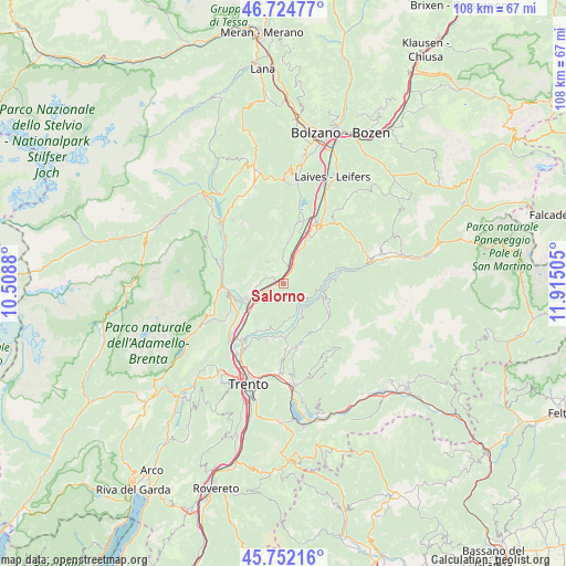
Salorno GPS coordinates[2]
46° 14' 26.232" North, 11° 12' 42.912" East
| Map corner | latitude | longitude |
|---|---|---|
| Upper-left | 46.72477°, | 10.5088° |
| Center: | 46.24062°, | 11.21192° |
| Lower-right: | 45.75216°, | 11.91505° |
| Map W x H: | 108.1×108.1 km | = 67.2×67.2mi |
| max Lat: | 47.04031° ⇑3.6% North |
| Salorno: | 46.24062° |
| min Lat: | ⇓96.4% South 35.50142° |
| min Long | Salorno | max Long |
| 6.69888° | 11.21192° | 18.48682° |
| W 45.7%⇐ | ⇒54.3% E |
Elevation
Elevation of Salorno is 214 m = 702 ft, and this is 92.7 m = 304 ft below average elevation for this country.
| Max E: |
2085 m = 6841 ft | 53.4% |
| Avg. | 306.7 m = 1006 ft | |
| Salorno | 214 m = 702 ft | |
Min E: |
-4 m = -13 ft | 46.6% |
See also: Italy elevation on elevation.city.
Geographical zone
Salorno is located in North temperate zone (between Tropic of Cancer and the Arctic Circle). Distance of this North polar circle is 2259.7 km =1404.1 mi to North.| Distance of | km | miles | from Salorno |
|---|---|---|---|
| North Pole | 4865.6 | 3023.3 | to North |
| Arctic Circle | 2259.7 | 1404.1 | to North |
| Tropic Cancer | 2535.6 | 1575.5 | to South |
| Equator | 5141.5 | 3194.8 | to South |


Nearby cities:
15 places around Salorno: (largest is in red/bold)
• Cembra
7.3 km =4.5 mi,  174°
174°
• Cortaccia sulla Strada del Vino
8.2 km =5.1 mi,  6°
6°
• Cortina sulla Strada del Vino
3.3 km =2.1 mi, 13°
• Faedo
6.6 km =4.1 mi,  216°
216°
• Faver
6.9 km =4.3 mi,  163°
163°
• Grauno
6.8 km =4.2 mi,  99°
99°
• Grumes
6.6 km =4.1 mi,  109°
109°
• Laghetti
4.4 km =2.7 mi,  29°
29°
• Magrè sulla Strada del Vino
5.3 km =3.3 mi,  358°
358°
• Mezzocorona
7.6 km =4.7 mi,  244°
244°
• Roverè della Luna
3.2 km =2 mi,  289°
289°
• San Michele All'Adige
8.4 km =5.2 mi,  227°
227°
• Segonzano
6.7 km =4.2 mi,  146°
146°
• Sover
8.3 km =5.2 mi, 104°
• Valda
5.5 km =3.4 mi,  132°
132°
Sources, notices
• [Note1] Compared only with cities in Italy existing in our database
• [Src1] Map data: © OpenStreetMap contributors (CC-BY-SA)
• [Src2] Other city data from geonames.org with taken over terms of usage.
• [Src3] Geographical zone / Annual Mean Temperature by Robert A. Rohde @ Wikipedia
