Valda geodata
Valda (Trentino-Alto Adige) is a seat of a third-order administrative division; located in Italy in Europe/Rome (GMT+2) time zone. With population of 214 people, there are 11060 cities with bigger population in this country. Compared to other cities in Italy, 96% of cities are located further ↓South; 53.6% of cities are located further →East and 92.7% of cities have lower elevation than Valda. Note1
Administrative division(s):
- Level 1: Trentino-Alto Adige
- Level 2: Provincia autonoma di Trento
- Level 3: Altavalle


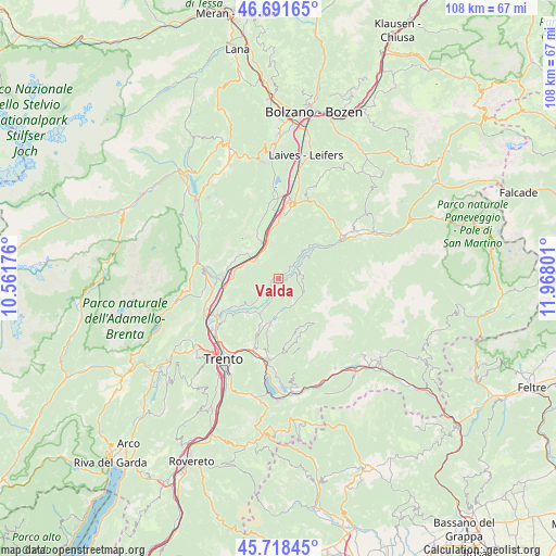
Valda GPS coordinates[2]
46° 12' 25.956" North, 11° 15' 53.568" East
| Map corner | latitude | longitude |
|---|---|---|
| Upper-left | 46.69165°, | 10.56176° |
| Center: | 46.20721°, | 11.26488° |
| Lower-right: | 45.71845°, | 11.96801° |
| Map W x H: | 108.2×108.2 km | = 67.2×67.2mi |
| max Lat: | 47.04031° ⇑4% North |
| Valda: | 46.20721° |
| min Lat: | ⇓96% South 35.50142° |
| min Long | Valda | max Long |
| 6.69888° | 11.26488° | 18.48682° |
| W 46.4%⇐ | ⇒53.6% E |
Elevation
Elevation of Valda is 790 m = 2592 ft, and this is 483.3 m = 1586 ft above average elevation for this country.
| Max E: |
2085 m = 6841 ft | 7.3% |
| Valda | 790 m 2592 ft | |
| Avg. | 306.7 m = 1006 ft | |
Min E: |
-4 m = -13 ft | 92.7% |
See also: Italy elevation on elevation.city.
Geographical zone
Valda is located in North temperate zone (between Tropic of Cancer and the Arctic Circle). Distance of this North polar circle is 2263.4 km =1406.4 mi to North.| Distance of | km | miles | from Valda |
|---|---|---|---|
| North Pole | 4869.3 | 3025.6 | to North |
| Arctic Circle | 2263.4 | 1406.4 | to North |
| Tropic Cancer | 2531.8 | 1573.2 | to South |
| Equator | 5137.8 | 3192.5 | to South |


Nearby cities:
15 places around Valda: (largest is in red/bold)
• Cembra
4.9 km =3 mi,  222°
222°
• Centrale
5.9 km =3.7 mi,  150°
150°
• Cortina sulla Strada del Vino
7.7 km =4.8 mi,  334°
334°
• Faver
3.6 km =2.2 mi, 216°
• Grauno
3.6 km =2.2 mi,  45°
45°
• Grumes
2.7 km =1.7 mi, 54°
• Laghetti
7.7 km =4.8 mi,  345°
345°
• Lases
7.7 km =4.8 mi,  207°
207°
• Lisignago
7.9 km =4.9 mi,  228°
228°
• Lona-Lases
7.8 km =4.8 mi, 206°
• Rizzolaga-Campolongo
6.5 km =4 mi,  175°
175°
• Salorno
5.5 km =3.4 mi,  312°
312°
• Segonzano
1.9 km =1.2 mi,  191°
191°
• Sover
4.2 km =2.6 mi,  67°
67°
• Valfloriana
7.6 km =4.7 mi, 51°
Sources, notices
• [Note1] Compared only with cities in Italy existing in our database
• [Src1] Map data: © OpenStreetMap contributors (CC-BY-SA)
• [Src2] Other city data from geonames.org with taken over terms of usage.
• [Src3] Geographical zone / Annual Mean Temperature by Robert A. Rohde @ Wikipedia
