Bonferraro geodata
Bonferraro (Veneto) is a populated place; located in Italy in Europe/Rome (GMT+2) time zone. With population of 1,323 people, there are 5559 cities with bigger population in this country. Compared to other cities in Italy, 64.6% of cities are located further ↓South; 57.2% of cities are located further →East and 89.6% of cities have higher elevation than Bonferraro. Note1


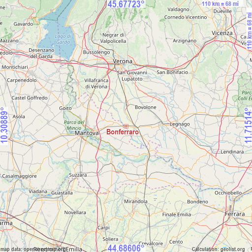
Bonferraro GPS coordinates[2]
45° 11' 1.68" North, 11° 0' 43.236" East
| Map corner | latitude | longitude |
|---|---|---|
| Upper-left | 45.67723°, | 10.30889° |
| Center: | 45.1838°, | 11.01201° |
| Lower-right: | 44.68606°, | 11.71514° |
| Map W x H: | 110.2×110.2 km | = 68.5×68.5mi |
| max Lat: | 47.04031° ⇑35.4% North |
| Bonferraro: | 45.1838° |
| min Lat: | ⇓64.6% South 35.50142° |
| min Long | Bonferraro | max Long |
| 6.69888° | 11.01201° | 18.48682° |
| W 42.8%⇐ | ⇒57.2% E |
Elevation
Elevation of Bonferraro is 19 m = 62 ft, and this is 287.7 m = 944 ft below average elevation for this country.
| Max E: |
2085 m = 6841 ft | 89.6% |
| Avg. | 306.7 m = 1006 ft | |
| Bonferraro | 19 m = 62 ft | |
Min E: |
-4 m = -13 ft | 10.4% |
See also: Italy elevation on elevation.city.
Geographical zone
Bonferraro is located in North temperate zone (between Tropic of Cancer and the Arctic Circle). Distance of this North polar circle is 2377.2 km =1477.1 mi to North.| Distance of | km | miles | from Bonferraro |
|---|---|---|---|
| North Pole | 4983.1 | 3096.4 | to North |
| Arctic Circle | 2377.2 | 1477.1 | to North |
| Tropic Cancer | 2418 | 1502.5 | to South |
| Equator | 5024 | 3121.8 | to South |


Nearby cities:
15 places around Bonferraro: (largest is in red/bold)
• Bionde
7.1 km =4.4 mi,  75°
75°
• Capitello
10.4 km =6.5 mi, 75°
• Castel d'Ario
3 km =1.9 mi,  278°
278°
• Castelbelforte
9.9 km =6.2 mi,  288°
288°
• Erbè
7.2 km =4.5 mi,  333°
333°
• Gazzo
9 km =5.6 mi,  267°
267°
• Isola della Scala
9.5 km =5.9 mi,  358°
358°
• Nogara
3.8 km =2.4 mi,  94°
94°
• Pellegrina
5 km =3.1 mi,  6°
6°
• Roncanova
8.5 km =5.3 mi,  122°
122°
• Roncoferraro
7.5 km =4.7 mi,  227°
227°
• Salizzole
9 km =5.6 mi,  46°
46°
• Sorgà
4.1 km =2.5 mi,  322°
322°
• Tarmassia
10.3 km =6.4 mi,  19°
19°
• Villimpenta
5 km =3.1 mi,  161°
161°
Sources, notices
• [Note1] Compared only with cities in Italy existing in our database
• [Src1] Map data: © OpenStreetMap contributors (CC-BY-SA)
• [Src2] Other city data from geonames.org with taken over terms of usage.
• [Src3] Geographical zone / Annual Mean Temperature by Robert A. Rohde @ Wikipedia
