Sorgà geodata
Sorgà (Veneto) is a seat of a third-order administrative division; located in Italy in Europe/Rome (GMT+2) time zone. With population of 552 people, there are 9430 cities with bigger population in this country. Compared to other cities in Italy, 65.3% of cities are located further ↓South; 57.6% of cities are located further →East and 87.8% of cities have higher elevation than Sorgà. Note1


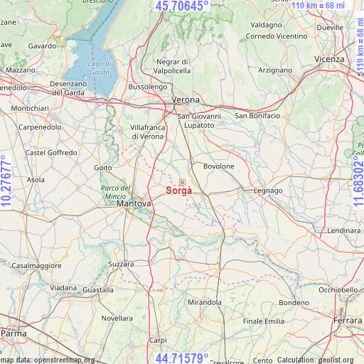
Sorgà GPS coordinates[2]
45° 12' 47.808" North, 10° 58' 47.604" East
| Map corner | latitude | longitude |
|---|---|---|
| Upper-left | 45.70645°, | 10.27677° |
| Center: | 45.21328°, | 10.97989° |
| Lower-right: | 44.71579°, | 11.68302° |
| Map W x H: | 110.2×110.1 km | = 68.5×68.4mi |
| max Lat: | 47.04031° ⇑34.7% North |
| Sorgà: | 45.21328° |
| min Lat: | ⇓65.3% South 35.50142° |
| min Long | Sorgà | max Long |
| 6.69888° | 10.97989° | 18.48682° |
| W 42.4%⇐ | ⇒57.6% E |
Elevation
Elevation of Sorgà is 23 m = 75 ft, and this is 283.7 m = 931 ft below average elevation for this country.
| Max E: |
2085 m = 6841 ft | 87.8% |
| Avg. | 306.7 m = 1006 ft | |
| Sorgà | 23 m = 75 ft | |
Min E: |
-4 m = -13 ft | 12.2% |
See also: Italy elevation on elevation.city.
Geographical zone
Sorgà is located in North temperate zone (between Tropic of Cancer and the Arctic Circle). Distance of this North polar circle is 2373.9 km =1475.1 mi to North.| Distance of | km | miles | from Sorgà |
|---|---|---|---|
| North Pole | 4979.8 | 3094.3 | to North |
| Arctic Circle | 2373.9 | 1475.1 | to North |
| Tropic Cancer | 2421.3 | 1504.5 | to South |
| Equator | 5027.2 | 3123.8 | to South |


Nearby cities:
15 places around Sorgà: (largest is in red/bold)
• Bionde
9.5 km =5.9 mi,  98°
98°
• Bonferraro
4.1 km =2.5 mi,  142°
142°
• Castel d'Ario
2.8 km =1.7 mi,  188°
188°
• Castelbelforte
6.8 km =4.2 mi,  268°
268°
• Erbè
3.3 km =2.1 mi,  348°
348°
• Gazzo
7.5 km =4.7 mi,  240°
240°
• Isola della Scala
6.6 km =4.1 mi,  19°
19°
• Nogara
7.2 km =4.5 mi,  119°
119°
• Pellegrina
3.5 km =2.2 mi,  61°
61°
• Roncoferraro
8.9 km =5.5 mi,  199°
199°
• Roncolevà
6.8 km =4.2 mi,  307°
307°
• Salizzole
9.5 km =5.9 mi,  71°
71°
• Tarmassia
8.7 km =5.4 mi,  42°
42°
• Trevenzuolo
7.2 km =4.5 mi,  330°
330°
• Villimpenta
9 km =5.6 mi,  153°
153°
Sources, notices
• [Note1] Compared only with cities in Italy existing in our database
• [Src1] Map data: © OpenStreetMap contributors (CC-BY-SA)
• [Src2] Other city data from geonames.org with taken over terms of usage.
• [Src3] Geographical zone / Annual Mean Temperature by Robert A. Rohde @ Wikipedia
