Roverbella geodata
Roverbella (Lombardy) is a seat of a third-order administrative division; located in Italy in Europe/Rome (GMT+2) time zone. With population of 3,864 people, there are 2474 cities with bigger population in this country. Compared to other cities in Italy, 66.6% of cities are located further ↓South; 60% of cities are located further →East and 82.2% of cities have higher elevation than Roverbella. Note1


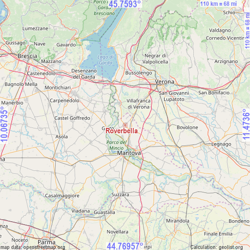
Roverbella GPS coordinates[2]
45° 15' 59.724" North, 10° 46' 13.692" East
| Map corner | latitude | longitude |
|---|---|---|
| Upper-left | 45.7593°, | 10.06735° |
| Center: | 45.26659°, | 10.77047° |
| Lower-right: | 44.76957°, | 11.4736° |
| Map W x H: | 110×110 km | = 68.4×68.4mi |
| max Lat: | 47.04031° ⇑33.4% North |
| Roverbella: | 45.26659° |
| min Lat: | ⇓66.6% South 35.50142° |
| min Long | Roverbella | max Long |
| 6.69888° | 10.77047° | 18.48682° |
| W 40%⇐ | ⇒60% E |
Elevation
Elevation of Roverbella is 41 m = 135 ft, and this is 265.7 m = 872 ft below average elevation for this country.
| Max E: |
2085 m = 6841 ft | 82.2% |
| Avg. | 306.7 m = 1006 ft | |
| Roverbella | 41 m = 135 ft | |
Min E: |
-4 m = -13 ft | 17.8% |
See also: Italy elevation on elevation.city.
Geographical zone
Roverbella is located in North temperate zone (between Tropic of Cancer and the Arctic Circle). Distance of this North polar circle is 2368 km =1471.4 mi to North.| Distance of | km | miles | from Roverbella |
|---|---|---|---|
| North Pole | 4973.9 | 3090.6 | to North |
| Arctic Circle | 2368 | 1471.4 | to North |
| Tropic Cancer | 2427.3 | 1508.3 | to South |
| Equator | 5033.2 | 3127.5 | to South |


Nearby cities:
15 places around Roverbella: (largest is in red/bold)
• Castiglione Mantovano
2.8 km =1.7 mi,  96°
96°
• Goito
8.7 km =5.4 mi,  258°
258°
• Grezzano
8.9 km =5.5 mi,  51°
51°
• Malavicina
3.8 km =2.4 mi,  19°
19°
• Marmirolo
5.4 km =3.4 mi,  192°
192°
• Mozzecane
5.8 km =3.6 mi,  37°
37°
• Pizzoletta
8.4 km =5.2 mi, 35°
• Pozzolo
5.8 km =3.6 mi,  313°
313°
• Pradelle
8.1 km =5 mi,  76°
76°
• Quaderni
7.1 km =4.4 mi,  12°
12°
• Rosegaferro
9.1 km =5.7 mi, 19°
• San Zeno
7.4 km =4.6 mi, 38°
• Sant'Antonio
8 km =5 mi,  166°
166°
• Soave
8.8 km =5.5 mi,  204°
204°
• Zona Artigianale Foroni
8.6 km =5.3 mi,  341°
341°
Sources, notices
• [Note1] Compared only with cities in Italy existing in our database
• [Src1] Map data: © OpenStreetMap contributors (CC-BY-SA)
• [Src2] Other city data from geonames.org with taken over terms of usage.
• [Src3] Geographical zone / Annual Mean Temperature by Robert A. Rohde @ Wikipedia
