Soave geodata
Soave (Lombardy) is a populated place; located in Italy in Europe/Rome (GMT+2) time zone. With population of 1,373 people, there are 5428 cities with bigger population in this country. Compared to other cities in Italy, 64.9% of cities are located further ↓South; 60.7% of cities are located further →East and 87.4% of cities have higher elevation than Soave. Note1
Administrative division(s):
- Level 1: Lombardy
- Level 2: Provincia di Mantova
- Level 3: Porto Mantovano


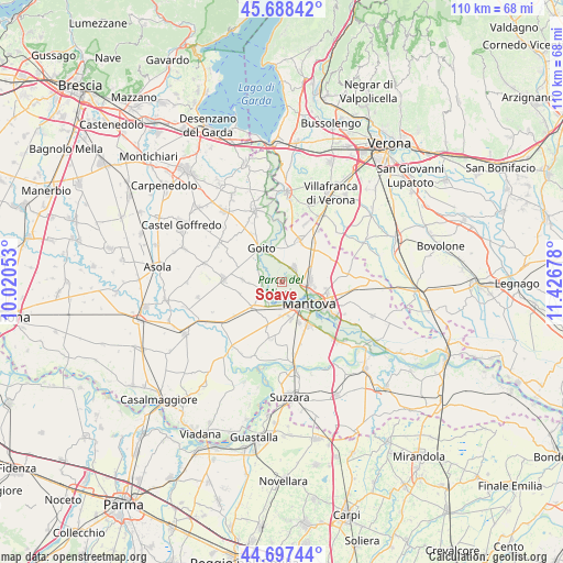
Soave GPS coordinates[2]
45° 11' 42.324" North, 10° 43' 25.14" East
| Map corner | latitude | longitude |
|---|---|---|
| Upper-left | 45.68842°, | 10.02053° |
| Center: | 45.19509°, | 10.72365° |
| Lower-right: | 44.69744°, | 11.42678° |
| Map W x H: | 110.2×110.2 km | = 68.5×68.5mi |
| max Lat: | 47.04031° ⇑35.1% North |
| Soave: | 45.19509° |
| min Lat: | ⇓64.9% South 35.50142° |
| min Long | Soave | max Long |
| 6.69888° | 10.72365° | 18.48682° |
| W 39.3%⇐ | ⇒60.7% E |
Elevation
Elevation of Soave is 24 m = 79 ft, and this is 282.7 m = 927 ft below average elevation for this country.
| Max E: |
2085 m = 6841 ft | 87.4% |
| Avg. | 306.7 m = 1006 ft | |
| Soave | 24 m = 79 ft | |
Min E: |
-4 m = -13 ft | 12.6% |
See also: Italy elevation on elevation.city.
Geographical zone
Soave is located in North temperate zone (between Tropic of Cancer and the Arctic Circle). Distance of this North polar circle is 2376 km =1476.4 mi to North.| Distance of | km | miles | from Soave |
|---|---|---|---|
| North Pole | 4981.8 | 3095.5 | to North |
| Arctic Circle | 2376 | 1476.4 | to North |
| Tropic Cancer | 2419.3 | 1503.3 | to South |
| Equator | 5025.2 | 3122.5 | to South |


Nearby cities:
15 places around Soave: (largest is in red/bold)
• Castellucchio
7.7 km =4.8 mi,  229°
229°
• Castiglione Mantovano
10 km =6.2 mi,  40°
40°
• Cerese
10 km =6.2 mi,  149°
149°
• Eremo
7.3 km =4.5 mi,  168°
168°
• Goito
7.9 km =4.9 mi,  321°
321°
• Grazie
5.1 km =3.2 mi,  206°
206°
• Levata
8.5 km =5.3 mi,  155°
155°
• Lunetta-Frassino
8.5 km =5.3 mi,  117°
117°
• Mantova
7 km =4.3 mi, 123°
• Marmirolo
3.7 km =2.3 mi, 43°
• Montanara
6.7 km =4.2 mi,  183°
183°
• Mottella
10.1 km =6.3 mi,  110°
110°
• Rodigo
7.7 km =4.8 mi,  273°
273°
• Roverbella
8.8 km =5.5 mi,  24°
24°
• Sant'Antonio
5.5 km =3.4 mi,  88°
88°
Sources, notices
• [Note1] Compared only with cities in Italy existing in our database
• [Src1] Map data: © OpenStreetMap contributors (CC-BY-SA)
• [Src2] Other city data from geonames.org with taken over terms of usage.
• [Src3] Geographical zone / Annual Mean Temperature by Robert A. Rohde @ Wikipedia
