Goito geodata
Goito (Lombardy) is a seat of a third-order administrative division; located in Italy in Europe/Rome (GMT+2) time zone. With population of 5,538 people, there are 1772 cities with bigger population in this country. Compared to other cities in Italy, 66.2% of cities are located further ↓South; 61.3% of cities are located further →East and 82.9% of cities have higher elevation than Goito. Note1


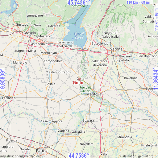
Goito GPS coordinates[2]
45° 15' 2.736" North, 10° 39' 40.356" East
| Map corner | latitude | longitude |
|---|---|---|
| Upper-left | 45.74361°, | 9.95809° |
| Center: | 45.25076°, | 10.66121° |
| Lower-right: | 44.7536°, | 11.36434° |
| Map W x H: | 110.1×110.1 km | = 68.4×68.4mi |
| max Lat: | 47.04031° ⇑33.8% North |
| Goito: | 45.25076° |
| min Lat: | ⇓66.2% South 35.50142° |
| min Long | Goito | max Long |
| 6.69888° | 10.66121° | 18.48682° |
| W 38.7%⇐ | ⇒61.3% E |
Elevation
Elevation of Goito is 38 m = 125 ft, and this is 268.7 m = 882 ft below average elevation for this country.
| Max E: |
2085 m = 6841 ft | 82.9% |
| Avg. | 306.7 m = 1006 ft | |
| Goito | 38 m = 125 ft | |
Min E: |
-4 m = -13 ft | 17.1% |
See also: Italy elevation on elevation.city.
Geographical zone
Goito is located in North temperate zone (between Tropic of Cancer and the Arctic Circle). Distance of this North polar circle is 2369.8 km =1472.5 mi to North.| Distance of | km | miles | from Goito |
|---|---|---|---|
| North Pole | 4975.6 | 3091.7 | to North |
| Arctic Circle | 2369.8 | 1472.5 | to North |
| Tropic Cancer | 2425.5 | 1507.1 | to South |
| Equator | 5031.4 | 3126.4 | to South |


Nearby cities:
15 places around Goito: (largest is in red/bold)
• Castellucchio
11.2 km =7 mi,  184°
184°
• Ceresara
7.3 km =4.5 mi,  280°
280°
• Cereta
6.2 km =3.9 mi,  345°
345°
• Cerlongo
3.2 km =2 mi,  343°
343°
• Gazoldo degli Ippoliti
8.6 km =5.3 mi,  228°
228°
• Grazie
11.1 km =6.9 mi,  166°
166°
• Guidizzolo
10.1 km =6.3 mi,  320°
320°
• Malavicina
11.2 km =7 mi,  61°
61°
• Marmirolo
8.2 km =5.1 mi,  115°
115°
• Piubega
10.5 km =6.5 mi,  255°
255°
• Pozzolo
7.2 km =4.5 mi,  37°
37°
• Rodigo
6.4 km =4 mi,  206°
206°
• Roverbella
8.7 km =5.4 mi,  78°
78°
• Soave
7.9 km =4.9 mi,  141°
141°
• Volta Mantovana
7.9 km =4.9 mi,  358°
358°
Sources, notices
• [Note1] Compared only with cities in Italy existing in our database
• [Src1] Map data: © OpenStreetMap contributors (CC-BY-SA)
• [Src2] Other city data from geonames.org with taken over terms of usage.
• [Src3] Geographical zone / Annual Mean Temperature by Robert A. Rohde @ Wikipedia
