Rome geodata
Rome (Latium) is a capital of a political entity; located in Italy in Europe/Rome (GMT+2) time zone. With population of 2,318,895 people, there are 0 cities with bigger population in this country. Compared to other cities in Italy, 71.3% of cities are located further ↑North; 62.5% of cities are located further ←West and 79.6% of cities have higher elevation than Rome. Note1
Administrative division(s):
- Level 1: Latium
- Level 2: Città metropolitana di Roma Capitale
- Level 3: Roma Capitale


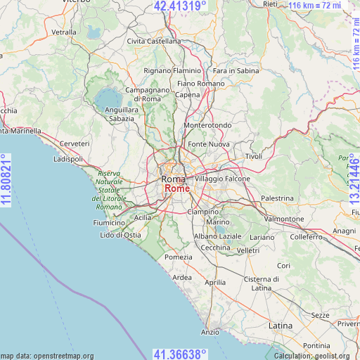
Rome GPS coordinates[2]
41° 53' 30.948" North, 12° 30' 40.788" East
| Map corner | latitude | longitude |
|---|---|---|
| Upper-left | 42.41319°, | 11.80821° |
| Center: | 41.89193°, | 12.51133° |
| Lower-right: | 41.36638°, | 13.21446° |
| Map W x H: | 116.4×116.4 km | = 72.3×72.3mi |
| max Lat: | 47.04031° ⇑71.3% North |
| Rome: | 41.89193° |
| min Lat: | ⇓28.7% South 35.50142° |
| min Long | Rome | max Long |
| 6.69888° | 12.51133° | 18.48682° |
| W 62.5%⇐ | ⇒37.5% E |
Elevation
Elevation of Rome is 52 m = 171 ft, and this is 254.7 m = 836 ft below average elevation for this country.
| Max E: |
2085 m = 6841 ft | 79.6% |
| Avg. | 306.7 m = 1006 ft | |
| Rome | 52 m = 171 ft | |
Min E: |
-4 m = -13 ft | 20.4% |
See also: Rome elevation on elevation.city.
Geographical zone
Rome is located in North temperate zone (between Tropic of Cancer and the Arctic Circle). Distance of this Northern Tropic circle is 2052 km =1275.1 mi to South.| Distance of | km | miles | from Rome |
|---|---|---|---|
| North Pole | 5349.1 | 3323.8 | to North |
| Arctic Circle | 2743.2 | 1704.5 | to North |
| Tropic Cancer | 2052 | 1275.1 | to South |
| Equator | 4657.9 | 2894.3 | to South |


Nearby cities:
15 places around Rome: (largest is in red/bold)
• Castel di Leva
13.1 km =8.1 mi,  167°
167°
• Ciampino
12.6 km =7.8 mi,  143°
143°
• Colle Monfortani
11.4 km =7.1 mi,  88°
88°
• Colle Verde
13 km =8.1 mi,  43°
43°
• Colleverde II
13.6 km =8.5 mi,  47°
47°
• Forno Casale
12.1 km =7.5 mi,  59°
59°
• La Massimina-Casal Lumbroso
12.9 km =8 mi,  260°
260°
• Laghetto
14.6 km =9.1 mi, 54°
• Marco Simone
13.3 km =8.3 mi, 57°
• Prato Lauro
11.2 km =7 mi, 42°
• Pratolungo
11.1 km =6.9 mi, 49°
• Selcetta
14.4 km =8.9 mi,  191°
191°
• Setteville
12.9 km =8 mi, 63°
• Tor Lupara
14.7 km =9.1 mi, 36°
• Vitinia
14.1 km =8.8 mi,  217°
217°
In other languages:
- In Spanish: Roma
- In German: Rom
- In Italian: Roma
- In Russian: Рим
- In Chinese: 罗马市
Sources, notices
• [Note1] Compared only with cities in Italy existing in our database
• [Src1] Map data: © OpenStreetMap contributors (CC-BY-SA)
• [Src2] Other city data from geonames.org with taken over terms of usage.
• [Src3] Geographical zone / Annual Mean Temperature by Robert A. Rohde @ Wikipedia
