Porto Torres geodata
Porto Torres (Sardinia) is a seat of a third-order administrative division; located in Italy in Europe/Rome (GMT+2) time zone. With population of 21,653 people, there are 409 cities with bigger population in this country. Compared to other cities in Italy, 81% of cities are located further ↑North; 89.1% of cities are located further →East and 88.3% of cities have higher elevation than Porto Torres. Note1


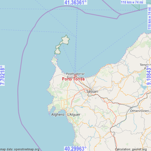
Porto Torres GPS coordinates[2]
40° 50' 1.5" North, 8° 24' 19.116" East
| Map corner | latitude | longitude |
|---|---|---|
| Upper-left | 41.36361°, | 7.70218° |
| Center: | 40.83375°, | 8.40531° |
| Lower-right: | 40.29963°, | 9.10843° |
| Map W x H: | 118.3×118.3 km | = 73.5×73.5mi |
| max Lat: | 47.04031° ⇑81% North |
| Porto Torres: | 40.83375° |
| min Lat: | ⇓19% South 35.50142° |
| min Long | Porto Torres | max Long |
| 6.69888° | 8.40531° | 18.48682° |
| W 10.9%⇐ | ⇒89.1% E |
Elevation
Elevation of Porto Torres is 22 m = 72 ft, and this is 284.7 m = 934 ft below average elevation for this country.
| Max E: |
2085 m = 6841 ft | 88.3% |
| Avg. | 306.7 m = 1006 ft | |
| Porto Torres | 22 m = 72 ft | |
Min E: |
-4 m = -13 ft | 11.7% |
See also: Italy elevation on elevation.city.
Geographical zone
Porto Torres is located in North temperate zone (between Tropic of Cancer and the Arctic Circle). Distance of this Northern Tropic circle is 1934.4 km =1202 mi to South.| Distance of | km | miles | from Porto Torres |
|---|---|---|---|
| North Pole | 5466.8 | 3396.9 | to North |
| Arctic Circle | 2860.9 | 1777.7 | to North |
| Tropic Cancer | 1934.4 | 1202 | to South |
| Equator | 4540.3 | 2821.2 | to South |


Nearby cities:
15 places around Porto Torres: (largest is in red/bold)
• Bancali
12 km =7.5 mi,  155°
155°
• Li Punti-San Giovanni
10.5 km =6.5 mi,  138°
138°
• Lu Bagnu
24.8 km =15.4 mi,  72°
72°
• Muros
24.8 km =15.4 mi,  133°
133°
• Olmedo
20.4 km =12.7 mi,  185°
185°
• Osilo
24.5 km =15.2 mi,  114°
114°
• Ossi
23.7 km =14.7 mi, 138°
• Ottava
8 km =5 mi, 132°
• Sassari
17.4 km =10.8 mi, 133°
• Sennori
16.6 km =10.3 mi, 107°
• Sorso
14.8 km =9.2 mi,  104°
104°
• Stintino
20.4 km =12.7 mi,  310°
310°
• Tissi
21.7 km =13.5 mi, 142°
• Uri
22.8 km =14.2 mi, 162°
• Usini
22 km =13.7 mi,  149°
149°
Sources, notices
• [Note1] Compared only with cities in Italy existing in our database
• [Src1] Map data: © OpenStreetMap contributors (CC-BY-SA)
• [Src2] Other city data from geonames.org with taken over terms of usage.
• [Src3] Geographical zone / Annual Mean Temperature by Robert A. Rohde @ Wikipedia
