Mortizza geodata
Mortizza (Emilia-Romagna) is a populated place; located in Italy in Europe/Rome (GMT+2) time zone. With population of 596 people, there are 9051 cities with bigger population in this country. Compared to other cities in Italy, 61.9% of cities are located further ↓South; 70.2% of cities are located further →East and 80.5% of cities have higher elevation than Mortizza. Note1
Administrative division(s):
- Level 1: Emilia-Romagna
- Level 2: Provincia di Piacenza
- Level 3: Piacenza


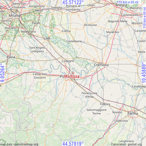
Mortizza GPS coordinates[2]
45° 4' 36.696" North, 9° 45' 20.736" East
| Map corner | latitude | longitude |
|---|---|---|
| Upper-left | 45.57122°, | 9.05264° |
| Center: | 45.07686°, | 9.75576° |
| Lower-right: | 44.57819°, | 10.45889° |
| Map W x H: | 110.4×110.4 km | = 68.6×68.6mi |
| max Lat: | 47.04031° ⇑38.1% North |
| Mortizza: | 45.07686° |
| min Lat: | ⇓61.9% South 35.50142° |
| min Long | Mortizza | max Long |
| 6.69888° | 9.75576° | 18.48682° |
| W 29.8%⇐ | ⇒70.2% E |
Elevation
Elevation of Mortizza is 47 m = 154 ft, and this is 259.7 m = 852 ft below average elevation for this country.
| Max E: |
2085 m = 6841 ft | 80.5% |
| Avg. | 306.7 m = 1006 ft | |
| Mortizza | 47 m = 154 ft | |
Min E: |
-4 m = -13 ft | 19.5% |
See also: Italy elevation on elevation.city.
Geographical zone
Mortizza is located in North temperate zone (between Tropic of Cancer and the Arctic Circle). Distance of this North polar circle is 2389.1 km =1484.5 mi to North.| Distance of | km | miles | from Mortizza |
|---|---|---|---|
| North Pole | 4995 | 3103.7 | to North |
| Arctic Circle | 2389.1 | 1484.5 | to North |
| Tropic Cancer | 2406.2 | 1495.1 | to South |
| Equator | 5012.1 | 3114.4 | to South |


Nearby cities:
15 places around Mortizza: (largest is in red/bold)
• Caorso
9.8 km =6.1 mi,  108°
108°
• Caselle Landi
4.2 km =2.6 mi,  47°
47°
• Castelnuovo Bocca d'Adda
9.3 km =5.8 mi,  65°
65°
• Corno Giovine
6.4 km =4 mi,  1°
1°
• Cornovecchio
7.5 km =4.7 mi,  27°
27°
• Fombio
9.3 km =5.8 mi,  320°
320°
• Guardamiglio
6.5 km =4 mi,  301°
301°
• Maleo
10 km =6.2 mi, 3°
• Meleti
7.9 km =4.9 mi, 52°
• Piacenza
5.6 km =3.5 mi,  240°
240°
• Pontenure
9.2 km =5.7 mi,  162°
162°
• Retegno
9.2 km =5.7 mi,  330°
330°
• San Fiorano
7.4 km =4.6 mi,  337°
337°
• San Rocco al Porto
4.6 km =2.9 mi,  277°
277°
• Santo Stefano Lodigiano
4.9 km =3 mi, 340°
Sources, notices
• [Note1] Compared only with cities in Italy existing in our database
• [Src1] Map data: © OpenStreetMap contributors (CC-BY-SA)
• [Src2] Other city data from geonames.org with taken over terms of usage.
• [Src3] Geographical zone / Annual Mean Temperature by Robert A. Rohde @ Wikipedia
