Castelnuovo Berardenga geodata
Castelnuovo Berardenga (Tuscany) is a seat of a third-order administrative division; located in Italy in Europe/Rome (GMT+2) time zone. With population of 1,654 people, there are 4773 cities with bigger population in this country. Compared to other cities in Italy, 60.8% of cities are located further ↑North; 50.6% of cities are located further →East and 62.8% of cities have lower elevation than Castelnuovo Berardenga. Note1
Administrative division(s):
- Level 1: Tuscany
- Level 2: Provincia di Siena
- Level 3: Castelnuovo Berardenga
Current local time in Castelnuovo Berardenga:
08:34 PM, WednesdayDifference from your time zone: hours


Castelnuovo Berardenga GPS coordinates[2]
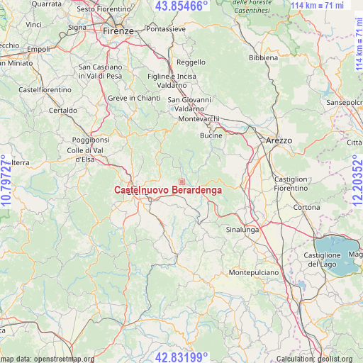
43° 20' 43.728" North, 11° 30' 1.404" East
| Map corner | latitude | longitude |
|---|---|---|
| Upper-left | 43.85466°, | 10.79727° |
| Center: | 43.34548°, | 11.50039° |
| Lower-right: | 42.83199°, | 12.20352° |
| Map W x H: | 113.7×113.7 km | = 70.6×70.6mi |
| max Lat: | 47.04031° ⇑60.8% North |
| Castelnuovo Berardenga: | 43.34548° |
| min Lat: | ⇓39.2% South 35.50142° |
| min Long | Castelnuovo Ber | max Long |
| 6.69888° | 11.50039° | 18.48682° |
| W 49.4%⇐ | ⇒50.6% E |
Elevation
Elevation of Castelnuovo Berardenga is 322 m = 1056 ft, and this is 15.3 m = 50 ft above average elevation for this country.
| Max E: |
2085 m = 6841 ft | 37.2% |
| Castelnuovo Berardenga | 322 m 1056 ft | |
| Avg. | 306.7 m = 1006 ft | |
Min E: |
-4 m = -13 ft | 62.8% |
See also: Italy elevation on elevation.city.
Geographical zone
Castelnuovo Berardenga is located in North temperate zone (between Tropic of Cancer and the Arctic Circle). Distance of this Northern Tropic circle is 2213.6 km =1375.5 mi to South.| Distance of | km | miles | from Castelnuovo Berardenga |
|---|---|---|---|
| North Pole | 5187.5 | 3223.4 | to North |
| Arctic Circle | 2581.6 | 1604.1 | to North |
| Tropic Cancer | 2213.6 | 1375.5 | to South |
| Equator | 4819.6 | 2994.8 | to South |


Nearby cities:
15 places around Castelnuovo Berardenga: (largest is in red/bold)
• Ambra
11.3 km =7 mi,  47°
47°
• Arbia
9.3 km =5.8 mi,  231°
231°
• Asciano
13.7 km =8.5 mi,  156°
156°
• Belverde
15.6 km =9.7 mi,  271°
271°
• Gaiole in Chianti
14.5 km =9 mi,  338°
338°
• Isola D'Arbia
13.8 km =8.6 mi, 225°
• Monteaperti
6 km =3.7 mi,  249°
249°
• Monteroni d'Arbia
14.3 km =8.9 mi,  206°
206°
• Pianella
6.9 km =4.3 mi,  277°
277°
• Ponte A Bozzone
10.3 km =6.4 mi, 271°
• Ponte A Tressa
13.5 km =8.4 mi,  219°
219°
• Rapolano Terme
10 km =6.2 mi,  124°
124°
• Serre di Rapolano
13.6 km =8.5 mi,  136°
136°
• Siena
14.1 km =8.8 mi,  257°
257°
• Taverne D'Arbia
10.2 km =6.3 mi,  236°
236°
Sources, notices
• [Note1] Compared only with cities in Italy existing in our database
• [Src1] Map data: © OpenStreetMap contributors (CC-BY-SA)
• [Src2] Other city data from geonames.org with taken over terms of usage.
• [Src3] Geographical zone / Annual Mean Temperature by Robert A. Rohde @ Wikipedia
