Pollein geodata
Pollein (Aosta Valley) is a seat of a third-order administrative division; located in Italy in Europe/Rome (GMT+2) time zone. With population of 1,167 people, there are 6065 cities with bigger population in this country. Compared to other cities in Italy, 82.6% of cities are located further ↓South; 98.6% of cities are located further →East and 83.9% of cities have lower elevation than Pollein. Note1


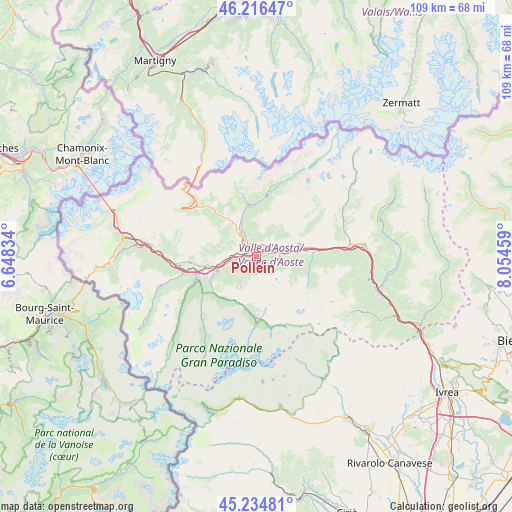
Pollein GPS coordinates[2]
45° 43' 40.08" North, 7° 21' 5.256" East
| Map corner | latitude | longitude |
|---|---|---|
| Upper-left | 46.21647°, | 6.64834° |
| Center: | 45.7278°, | 7.35146° |
| Lower-right: | 45.23481°, | 8.05459° |
| Map W x H: | 109.2×109.1 km | = 67.9×67.8mi |
| max Lat: | 47.04031° ⇑17.4% North |
| Pollein: | 45.7278° |
| min Lat: | ⇓82.6% South 35.50142° |
| min Long | Pollein | max Long |
| 6.69888° | 7.35146° | 18.48682° |
| W 1.4%⇐ | ⇒98.6% E |
Elevation
Elevation of Pollein is 589 m = 1932 ft, and this is 282.3 m = 926 ft above average elevation for this country.
| Max E: |
2085 m = 6841 ft | 16.1% |
| Pollein | 589 m 1932 ft | |
| Avg. | 306.7 m = 1006 ft | |
Min E: |
-4 m = -13 ft | 83.9% |
See also: Italy elevation on elevation.city.
Geographical zone
Pollein is located in North temperate zone (between Tropic of Cancer and the Arctic Circle). Distance of this North polar circle is 2316.7 km =1439.5 mi to North.| Distance of | km | miles | from Pollein |
|---|---|---|---|
| North Pole | 4922.6 | 3058.8 | to North |
| Arctic Circle | 2316.7 | 1439.5 | to North |
| Tropic Cancer | 2478.5 | 1540.1 | to South |
| Equator | 5084.5 | 3159.4 | to South |


Nearby cities:
15 places around Pollein: (largest is in red/bold)
• Aosta
2.9 km =1.8 mi,  292°
292°
• Arpuilles
4.6 km =2.9 mi,  309°
309°
• Chantignan
5.2 km =3.2 mi,  63°
63°
• Charvensod
2.3 km =1.4 mi,  248°
248°
• Chef-Lieu
2.6 km =1.6 mi,  3°
3°
• Grand Brissogne
3.2 km =2 mi,  94°
94°
• Gressan
4.6 km =2.9 mi,  259°
259°
• Neyran-Etabloz
4.9 km =3 mi, 85°
• Plan Felinaz-Felinaz
1.3 km =0.8 mi,  267°
267°
• Pont Suaz-Ampaillant
2.5 km =1.6 mi, 267°
• Porossan
3.6 km =2.2 mi,  328°
328°
• Quart
5.2 km =3.2 mi,  73°
73°
• Saint-Christophe
2.9 km =1.8 mi,  353°
353°
• Villair-Amerique
3.7 km =2.3 mi,  53°
53°
• Villefranche
5.2 km =3.2 mi, 74°
Sources, notices
• [Note1] Compared only with cities in Italy existing in our database
• [Src1] Map data: © OpenStreetMap contributors (CC-BY-SA)
• [Src2] Other city data from geonames.org with taken over terms of usage.
• [Src3] Geographical zone / Annual Mean Temperature by Robert A. Rohde @ Wikipedia
