Gressan geodata
Gressan (Aosta Valley) is a seat of a third-order administrative division; located in Italy in Europe/Rome (GMT+2) time zone. With population of 2,867 people, there are 3150 cities with bigger population in this country. Compared to other cities in Italy, 82.2% of cities are located further ↓South; 99% of cities are located further →East and 85.2% of cities have lower elevation than Gressan. Note1


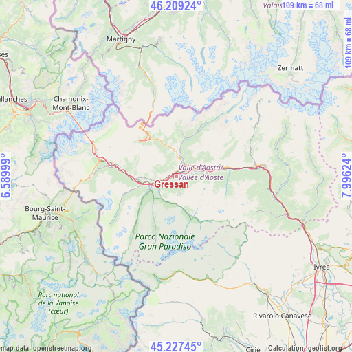
Gressan GPS coordinates[2]
45° 43' 13.8" North, 7° 17' 35.196" East
| Map corner | latitude | longitude |
|---|---|---|
| Upper-left | 46.20924°, | 6.58999° |
| Center: | 45.7205°, | 7.29311° |
| Lower-right: | 45.22745°, | 7.99624° |
| Map W x H: | 109.2×109.2 km | = 67.9×67.9mi |
| max Lat: | 47.04031° ⇑17.8% North |
| Gressan: | 45.7205° |
| min Lat: | ⇓82.2% South 35.50142° |
| min Long | Gressan | max Long |
| 6.69888° | 7.29311° | 18.48682° |
| W 1%⇐ | ⇒99% E |
Elevation
Elevation of Gressan is 618 m = 2028 ft, and this is 311.3 m = 1021 ft above average elevation for this country.
| Max E: |
2085 m = 6841 ft | 14.8% |
| Gressan | 618 m 2028 ft | |
| Avg. | 306.7 m = 1006 ft | |
Min E: |
-4 m = -13 ft | 85.2% |
See also: Italy elevation on elevation.city.
Geographical zone
Gressan is located in North temperate zone (between Tropic of Cancer and the Arctic Circle). Distance of this North polar circle is 2317.5 km =1440 mi to North.| Distance of | km | miles | from Gressan |
|---|---|---|---|
| North Pole | 4923.4 | 3059.3 | to North |
| Arctic Circle | 2317.5 | 1440 | to North |
| Tropic Cancer | 2477.7 | 1539.6 | to South |
| Equator | 5083.6 | 3158.8 | to South |


Nearby cities:
15 places around Gressan: (largest is in red/bold)
• Aosta
2.7 km =1.7 mi,  44°
44°
• Arpuilles
3.9 km =2.4 mi,  15°
15°
• Aymavilles
4.2 km =2.6 mi,  239°
239°
• Charvensod
2.4 km =1.5 mi,  90°
90°
• Jovencan
1.7 km =1.1 mi,  248°
248°
• Montan-Angelin-Arensod
1.5 km =0.9 mi,  303°
303°
• Plan Felinaz-Felinaz
3.3 km =2.1 mi,  76°
76°
• Pollein
4.6 km =2.9 mi, 79°
• Pont Suaz-Ampaillant
2.1 km =1.3 mi,  70°
70°
• Porossan
4.7 km =2.9 mi,  34°
34°
• Saint Maurice
2.9 km =1.8 mi,  263°
263°
• Saint-Christophe
5.6 km =3.5 mi,  48°
48°
• Saint-Pierre
5.2 km =3.2 mi, 259°
• Variney Chez Roncoz
5.5 km =3.4 mi,  14°
14°
• Ville Sur Sarre
3 km =1.9 mi, 298°
Sources, notices
• [Note1] Compared only with cities in Italy existing in our database
• [Src1] Map data: © OpenStreetMap contributors (CC-BY-SA)
• [Src2] Other city data from geonames.org with taken over terms of usage.
• [Src3] Geographical zone / Annual Mean Temperature by Robert A. Rohde @ Wikipedia
