Pont Suaz-Ampaillant geodata
Pont Suaz-Ampaillant (Aosta Valley) is a populated place; located in Italy in Europe/Rome (GMT+2) time zone. With population of 663 people, there are 8542 cities with bigger population in this country. Compared to other cities in Italy, 82.5% of cities are located further ↓South; 98.9% of cities are located further →East and 83.8% of cities have lower elevation than Pont Suaz-Ampaillant. Note1
Current local time in Pont Suaz-Ampaillant:
08:20 PM, WednesdayDifference from your time zone: hours


Pont Suaz-Ampaillant GPS coordinates[2]
45° 43' 36.696" North, 7° 19' 7.464" East
| Map corner | latitude | longitude |
|---|---|---|
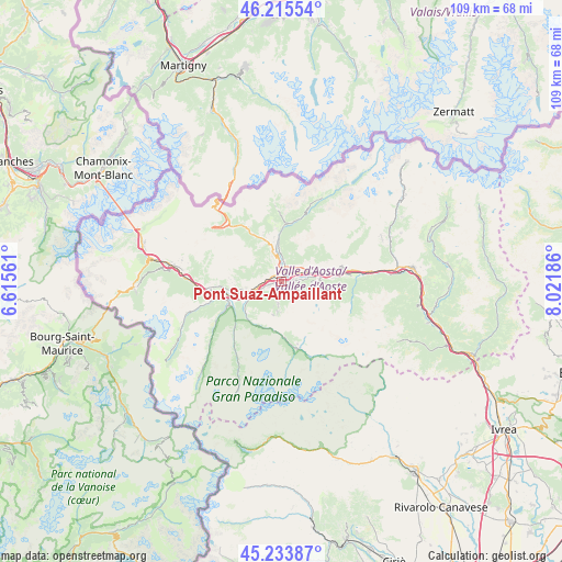
| Upper-left | 46.21554°, | 6.61561° |
| Center: | 45.72686°, | 7.31874° |
| Lower-right: | 45.23387°, | 8.02186° |
| Map W x H: | 109.2×109.2 km | = 67.9×67.9mi |
| max Lat: | 47.04031° ⇑17.5% North |
| Pont Suaz-Ampaillant: | 45.72686° |
| min Lat: | ⇓82.5% South 35.50142° |
| min Long | Pont Suaz-Ampai | max Long |
| 6.69888° | 7.31874° | 18.48682° |
| W 1.1%⇐ | ⇒98.9% E |
Elevation
Elevation of Pont Suaz-Ampaillant is 588 m = 1929 ft, and this is 281.3 m = 923 ft above average elevation for this country.
| Max E: |
2085 m = 6841 ft | 16.2% |
| Pont Suaz-Ampaillant | 588 m 1929 ft | |
| Avg. | 306.7 m = 1006 ft | |
Min E: |
-4 m = -13 ft | 83.8% |
See also: Italy elevation on elevation.city.
Geographical zone
Pont Suaz-Ampaillant is located in North temperate zone (between Tropic of Cancer and the Arctic Circle). Distance of this North polar circle is 2316.8 km =1439.6 mi to North.| Distance of | km | miles | from Pont Suaz-Ampaillant |
|---|---|---|---|
| North Pole | 4922.7 | 3058.8 | to North |
| Arctic Circle | 2316.8 | 1439.6 | to North |
| Tropic Cancer | 2478.4 | 1540 | to South |
| Equator | 5084.4 | 3159.3 | to South |


Nearby cities:
15 places around Pont Suaz-Ampaillant: (largest is in red/bold)
• Aosta
1.2 km =0.7 mi,  354°
354°
• Arpuilles
3.2 km =2 mi,  342°
342°
• Charvensod
0.9 km =0.6 mi,  149°
149°
• Chef-Lieu
3.8 km =2.4 mi,  45°
45°
• Grand Brissogne
5.7 km =3.5 mi,  91°
91°
• Gressan
2.1 km =1.3 mi,  250°
250°
• Jovencan
3.8 km =2.4 mi, 249°
• Montan-Angelin-Arensod
3.3 km =2.1 mi,  272°
272°
• Plan Felinaz-Felinaz
1.2 km =0.7 mi, 87°
• Pollein
2.5 km =1.6 mi, 87°
• Porossan
3.3 km =2.1 mi,  11°
11°
• Saint Maurice
5 km =3.1 mi,  258°
258°
• Saint-Christophe
3.7 km =2.3 mi,  36°
36°
• Variney Chez Roncoz
4.7 km =2.9 mi, 352°
• Ville Sur Sarre
4.7 km =2.9 mi,  278°
278°
Sources, notices
• [Note1] Compared only with cities in Italy existing in our database
• [Src1] Map data: © OpenStreetMap contributors (CC-BY-SA)
• [Src2] Other city data from geonames.org with taken over terms of usage.
• [Src3] Geographical zone / Annual Mean Temperature by Robert A. Rohde @ Wikipedia
