Plan Felinaz-Felinaz geodata
Plan Felinaz-Felinaz (Aosta Valley) is a populated place; located in Italy in Europe/Rome (GMT+2) time zone. With population of 937 people, there are 6945 cities with bigger population in this country. Compared to other cities in Italy, 82.6% of cities are located further ↓South; 98.7% of cities are located further →East and 82.3% of cities have lower elevation than Plan Felinaz-Felinaz. Note1
Current local time in Plan Felinaz-Felinaz:
08:20 PM, WednesdayDifference from your time zone: hours


Plan Felinaz-Felinaz GPS coordinates[2]
45° 43' 38.532" North, 7° 20' 3.804" East
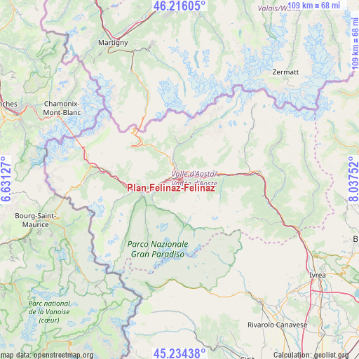
| Map corner | latitude | longitude |
|---|---|---|
| Upper-left | 46.21605°, | 6.63127° |
| Center: | 45.72737°, | 7.33439° |
| Lower-right: | 45.23438°, | 8.03752° |
| Map W x H: | 109.2×109.1 km | = 67.9×67.8mi |
| max Lat: | 47.04031° ⇑17.4% North |
| Plan Felinaz-Felinaz: | 45.72737° |
| min Lat: | ⇓82.6% South 35.50142° |
| min Long | Plan Felinaz-Fe | max Long |
| 6.69888° | 7.33439° | 18.48682° |
| W 1.3%⇐ | ⇒98.7% E |
Elevation
Elevation of Plan Felinaz-Felinaz is 559 m = 1834 ft, and this is 252.3 m = 828 ft above average elevation for this country.
| Max E: |
2085 m = 6841 ft | 17.7% |
| Plan Felinaz-Felinaz | 559 m 1834 ft | |
| Avg. | 306.7 m = 1006 ft | |
Min E: |
-4 m = -13 ft | 82.3% |
See also: Italy elevation on elevation.city.
Geographical zone
Plan Felinaz-Felinaz is located in North temperate zone (between Tropic of Cancer and the Arctic Circle). Distance of this North polar circle is 2316.8 km =1439.6 mi to North.| Distance of | km | miles | from Plan Felinaz-Felinaz |
|---|---|---|---|
| North Pole | 4922.7 | 3058.8 | to North |
| Arctic Circle | 2316.8 | 1439.6 | to North |
| Tropic Cancer | 2478.5 | 1540.1 | to South |
| Equator | 5084.4 | 3159.3 | to South |


Nearby cities:
15 places around Plan Felinaz-Felinaz: (largest is in red/bold)
• Aosta
1.8 km =1.1 mi,  310°
310°
• Arpuilles
3.7 km =2.3 mi,  323°
323°
• Charvensod
1.1 km =0.7 mi,  224°
224°
• Chef-Lieu
3 km =1.9 mi,  29°
29°
• Grand Brissogne
4.5 km =2.8 mi,  92°
92°
• Gressan
3.3 km =2.1 mi,  256°
256°
• Jovencan
5 km =3.1 mi,  253°
253°
• Montan-Angelin-Arensod
4.5 km =2.8 mi,  271°
271°
• Pollein
1.3 km =0.8 mi, 87°
• Pont Suaz-Ampaillant
1.2 km =0.7 mi, 267°
• Porossan
3.2 km =2 mi,  349°
349°
• Saint-Christophe
3.1 km =1.9 mi,  18°
18°
• Variney Chez Roncoz
5 km =3.1 mi,  338°
338°
• Villair-Amerique
4.9 km =3 mi,  62°
62°
• Ville Sur Sarre
5.9 km =3.7 mi,  276°
276°
Sources, notices
• [Note1] Compared only with cities in Italy existing in our database
• [Src1] Map data: © OpenStreetMap contributors (CC-BY-SA)
• [Src2] Other city data from geonames.org with taken over terms of usage.
• [Src3] Geographical zone / Annual Mean Temperature by Robert A. Rohde @ Wikipedia
