Chef-Lieu geodata
Chef-Lieu (Aosta Valley) is a seat of a third-order administrative division; located in Italy in Europe/Rome (GMT+2) time zone. With population of 2,827 people, there are 3184 cities with bigger population in this country. Compared to other cities in Italy, 83.6% of cities are located further ↓South; 98.6% of cities are located further →East and 88.9% of cities have lower elevation than Chef-Lieu. Note1


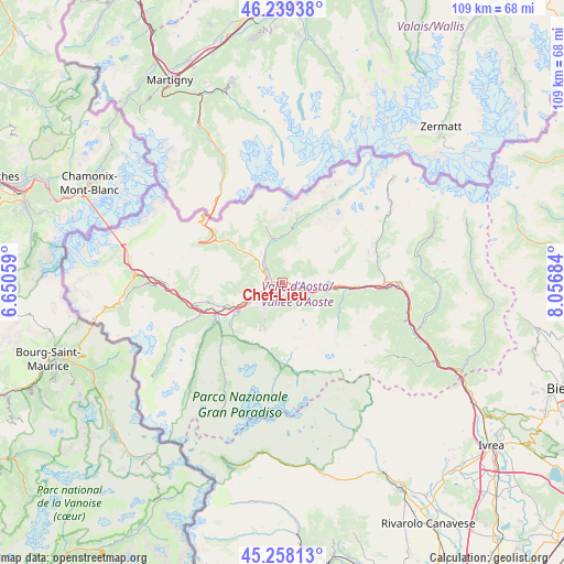
Chef-Lieu GPS coordinates[2]
45° 45' 3.276" North, 7° 21' 13.392" East
| Map corner | latitude | longitude |
|---|---|---|
| Upper-left | 46.23938°, | 6.65059° |
| Center: | 45.75091°, | 7.35372° |
| Lower-right: | 45.25813°, | 8.05684° |
| Map W x H: | 109.1×109.1 km | = 67.8×67.8mi |
| max Lat: | 47.04031° ⇑16.4% North |
| Chef-Lieu: | 45.75091° |
| min Lat: | ⇓83.6% South 35.50142° |
| min Long | Chef-Lieu | max Long |
| 6.69888° | 7.35372° | 18.48682° |
| W 1.4%⇐ | ⇒98.6% E |
Elevation
Elevation of Chef-Lieu is 692 m = 2270 ft, and this is 385.3 m = 1264 ft above average elevation for this country.
| Max E: |
2085 m = 6841 ft | 11.1% |
| Chef-Lieu | 692 m 2270 ft | |
| Avg. | 306.7 m = 1006 ft | |
Min E: |
-4 m = -13 ft | 88.9% |
See also: Italy elevation on elevation.city.
Geographical zone
Chef-Lieu is located in North temperate zone (between Tropic of Cancer and the Arctic Circle). Distance of this North polar circle is 2314.1 km =1437.9 mi to North.| Distance of | km | miles | from Chef-Lieu |
|---|---|---|---|
| North Pole | 4920 | 3057.1 | to North |
| Arctic Circle | 2314.1 | 1437.9 | to North |
| Tropic Cancer | 2481.1 | 1541.7 | to South |
| Equator | 5087 | 3160.9 | to South |


Nearby cities:
15 places around Chef-Lieu: (largest is in red/bold)
• Aosta
3.2 km =2 mi,  242°
242°
• Arpuilles
3.7 km =2.3 mi,  275°
275°
• Chantignan
4.5 km =2.8 mi,  93°
93°
• Charvensod
4.1 km =2.5 mi,  213°
213°
• Grand Brissogne
4.1 km =2.5 mi,  132°
132°
• La Cretaz-Roisan
4.8 km =3 mi,  319°
319°
• Plan Felinaz-Felinaz
3 km =1.9 mi, 209°
• Pollein
2.6 km =1.6 mi,  183°
183°
• Pont Suaz-Ampaillant
3.8 km =2.4 mi,  225°
225°
• Porossan
2.1 km =1.3 mi, 284°
• Quart
4.9 km =3 mi,  103°
103°
• Saint-Christophe
0.6 km =0.4 mi,  304°
304°
• Variney Chez Roncoz
3.9 km =2.4 mi, 300°
• Villair-Amerique
2.8 km =1.7 mi, 96°
• Villefranche
5 km =3.1 mi, 103°
Sources, notices
• [Note1] Compared only with cities in Italy existing in our database
• [Src1] Map data: © OpenStreetMap contributors (CC-BY-SA)
• [Src2] Other city data from geonames.org with taken over terms of usage.
• [Src3] Geographical zone / Annual Mean Temperature by Robert A. Rohde @ Wikipedia
