Pietole geodata
Pietole (Lombardy) is a populated place; located in Italy in Europe/Rome (GMT+2) time zone. With population of 721 people, there are 8146 cities with bigger population in this country. Compared to other cities in Italy, 62.8% of cities are located further ↓South; 59.5% of cities are located further →East and 88.7% of cities have higher elevation than Pietole. Note1


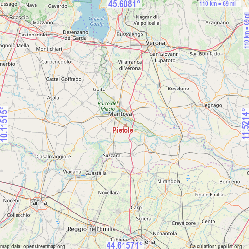
Pietole GPS coordinates[2]
45° 6' 50.616" North, 10° 49' 5.772" East
| Map corner | latitude | longitude |
|---|---|---|
| Upper-left | 45.6081°, | 10.11515° |
| Center: | 45.11406°, | 10.81827° |
| Lower-right: | 44.61571°, | 11.5214° |
| Map W x H: | 110.3×110.3 km | = 68.5×68.5mi |
| max Lat: | 47.04031° ⇑37.2% North |
| Pietole: | 45.11406° |
| min Lat: | ⇓62.8% South 35.50142° |
| min Long | Pietole | max Long |
| 6.69888° | 10.81827° | 18.48682° |
| W 40.5%⇐ | ⇒59.5% E |
Elevation
Elevation of Pietole is 21 m = 69 ft, and this is 285.7 m = 937 ft below average elevation for this country.
| Max E: |
2085 m = 6841 ft | 88.7% |
| Avg. | 306.7 m = 1006 ft | |
| Pietole | 21 m = 69 ft | |
Min E: |
-4 m = -13 ft | 11.3% |
See also: Italy elevation on elevation.city.
Geographical zone
Pietole is located in North temperate zone (between Tropic of Cancer and the Arctic Circle). Distance of this North polar circle is 2385 km =1482 mi to North.| Distance of | km | miles | from Pietole |
|---|---|---|---|
| North Pole | 4990.8 | 3101.1 | to North |
| Arctic Circle | 2385 | 1482 | to North |
| Tropic Cancer | 2410.3 | 1497.7 | to South |
| Equator | 5016.2 | 3116.9 | to South |


Nearby cities:
15 places around Pietole: (largest is in red/bold)
• Bagnolo San Vito
5.4 km =3.4 mi,  121°
121°
• Barbasso
7 km =4.3 mi,  84°
84°
• Cappelletta
3.3 km =2.1 mi,  252°
252°
• Cerese
2.4 km =1.5 mi,  281°
281°
• Eremo
6.2 km =3.9 mi,  287°
287°
• Formigosa
3.9 km =2.4 mi,  71°
71°
• Levata
4.1 km =2.5 mi, 287°
• Lunetta-Frassino
5.1 km =3.2 mi,  2°
2°
• Mantova
5.4 km =3.4 mi,  342°
342°
• Montanara
8.2 km =5.1 mi, 286°
• Mottella
5.9 km =3.7 mi,  20°
20°
• Romanore
7.1 km =4.4 mi,  222°
222°
• San Biagio
2.8 km =1.7 mi,  125°
125°
• San Cataldo
5.5 km =3.4 mi,  210°
210°
• Stradella
7.8 km =4.8 mi,  33°
33°
Sources, notices
• [Note1] Compared only with cities in Italy existing in our database
• [Src1] Map data: © OpenStreetMap contributors (CC-BY-SA)
• [Src2] Other city data from geonames.org with taken over terms of usage.
• [Src3] Geographical zone / Annual Mean Temperature by Robert A. Rohde @ Wikipedia
