Mottella geodata
Mottella (Lombardy) is a seat of a third-order administrative division; located in Italy in Europe/Rome (GMT+2) time zone. With population of 8,019 people, there are 1211 cities with bigger population in this country. Compared to other cities in Italy, 64.2% of cities are located further ↓South; 59.2% of cities are located further →East and 87% of cities have higher elevation than Mottella. Note1
Administrative division(s):
- Level 1: Lombardy
- Level 2: Provincia di Mantova
- Level 3: San Giorgio di Mantova


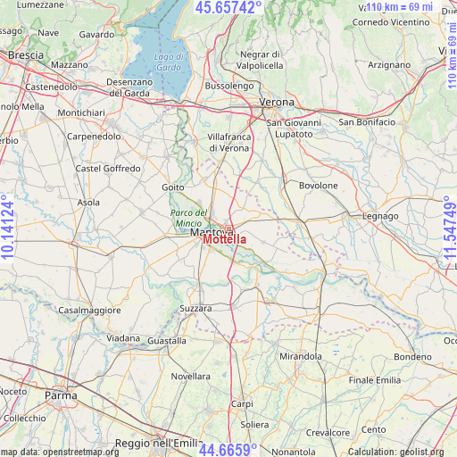
Mottella GPS coordinates[2]
45° 9' 49.752" North, 10° 50' 39.696" East
| Map corner | latitude | longitude |
|---|---|---|
| Upper-left | 45.65742°, | 10.14124° |
| Center: | 45.16382°, | 10.84436° |
| Lower-right: | 44.6659°, | 11.54749° |
| Map W x H: | 110.2×110.2 km | = 68.5×68.5mi |
| max Lat: | 47.04031° ⇑35.8% North |
| Mottella: | 45.16382° |
| min Lat: | ⇓64.2% South 35.50142° |
| min Long | Mottella | max Long |
| 6.69888° | 10.84436° | 18.48682° |
| W 40.8%⇐ | ⇒59.2% E |
Elevation
Elevation of Mottella is 25 m = 82 ft, and this is 281.7 m = 924 ft below average elevation for this country.
| Max E: |
2085 m = 6841 ft | 87% |
| Avg. | 306.7 m = 1006 ft | |
| Mottella | 25 m = 82 ft | |
Min E: |
-4 m = -13 ft | 13% |
See also: Italy elevation on elevation.city.
Geographical zone
Mottella is located in North temperate zone (between Tropic of Cancer and the Arctic Circle). Distance of this North polar circle is 2379.4 km =1478.5 mi to North.| Distance of | km | miles | from Mottella |
|---|---|---|---|
| North Pole | 4985.3 | 3097.7 | to North |
| Arctic Circle | 2379.4 | 1478.5 | to North |
| Tropic Cancer | 2415.8 | 1501.1 | to South |
| Equator | 5021.7 | 3120.3 | to South |


Nearby cities:
15 places around Mottella: (largest is in red/bold)
• Bagnolo San Vito
8.7 km =5.4 mi,  162°
162°
• Barbasso
6.9 km =4.3 mi,  134°
134°
• Cappelletta
8.3 km =5.2 mi,  218°
218°
• Castelbelforte
6.6 km =4.1 mi,  35°
35°
• Cerese
6.7 km =4.2 mi, 220°
• Formigosa
4.6 km =2.9 mi, 159°
• Gazzo
4.5 km =2.8 mi,  66°
66°
• Levata
7.4 km =4.6 mi,  234°
234°
• Lunetta-Frassino
1.9 km =1.2 mi,  257°
257°
• Mantova
3.7 km =2.3 mi, 263°
• Pietole
5.9 km =3.7 mi,  200°
200°
• Roncoferraro
8.2 km =5.1 mi,  110°
110°
• San Biagio
7.2 km =4.5 mi,  178°
178°
• Sant'Antonio
5.4 km =3.4 mi,  312°
312°
• Stradella
2.5 km =1.6 mi, 67°
Sources, notices
• [Note1] Compared only with cities in Italy existing in our database
• [Src1] Map data: © OpenStreetMap contributors (CC-BY-SA)
• [Src2] Other city data from geonames.org with taken over terms of usage.
• [Src3] Geographical zone / Annual Mean Temperature by Robert A. Rohde @ Wikipedia
